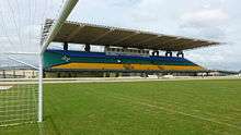
Zerão
 | |
| Full name | Estádio Milton Corrêa |
|---|---|
| Former names | Estádio Ayrton Senna |
| Location | Macapá, Amapá, Brazil |
| Owner | Amapá State Government |
| Capacity | 13,680[1] |
| Record attendance | 10,000 |
| Field size | 110x75 |
| Construction | |
| Built | 1990 |
| Opened | October 17, 1990 |
| Renovated | 2014 |
| Tenants | |
|
Amapá Clube Esporte Clube Macapá Oratório Recreativo Clube Trem Desportivo Clube Santos Futebol Clube (AP) São Paulo Futebol Clube (AP) | |
Estádio Milton Corrêa, usually known as Zerão [ˈzɛ.ɾɐ̃ũ], is a multi-purpose stadium located in Macapá, Brazil. It is used mostly for football matches and hosts the home matches of Amapá Clube, Esporte Clube Macapá, Oratório Recreativo Clube, Trem Desportivo Clube, Santos Futebol Clube (AP) and São Paulo Futebol Clube (AP).
Overview
The stadium has a maximum capacity of 10,000 people[1] and was built in 1990. The name (and the fame) came from the circumstance that the stadium lies on the Equator - zero latitude. The midfield line is aligned with the nearby Marco Zero Monument, though it is about 2 seconds N in the World Geodetic System 84.
Zerão is owned by the Amapá State Government. The stadium is named after Milton de Souza Corrêa, who was a former president of the Amapá State Football Federation. The stadium is nicknamed after the neighborhood where it is located, Marco Zero (the neighborhood is named Marco Zero ("mark 0" in English) as it is located on the Equator). Zerão means Big Zero, denoting the zeroth latitude - Equator.
History
In 1990, the work on Zerão was completed. It was named Estádio Ayrton Senna, after the Formula 1 driver. The inaugural match was played on October 17 of that year, when Independente beat Trem 1-0. The first goal of the stadium was scored by Independente's Mirandinha. The stadium's attendance record currently stands at 10,000, set on that match.
In 1994, after Milton de Souza Corrêa's death, the stadium was renamed to its current name, Estádio Milton Corrêa.
The Zerão closed in 2007, and after seven years of remodeling, the stadium reopened in 2014.[2]
References
- 1 2 "CNEF - Cadastro Nacional de Estádios de Futebol" (PDF) (in Portuguese). Confederação Brasileira de Futebol. Archived from the original (PDF) on October 14, 2009. Retrieved December 25, 2010.
- ↑ Após 7 anos, estádio dividido pela linha do Equador é reaberto no AP (in Portuguese)
- Enciclopédia do Futebol Brasileiro, Volume 2 - Lance, Rio de Janeiro: Aretê Editorial S/A, 2001.
External links
Coordinates: 0°00′02″N 51°04′51″W / 0.00056°N 51.08083°W