Esquibien
| Esquibien An Eskevien | ||
|---|---|---|
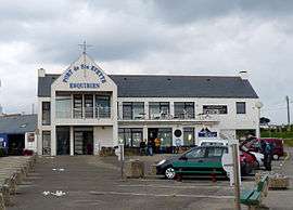 The port of Saint Evette, which has a pier for services to the Île de Sein | ||
| ||
 Esquibien Location within Brittany region  Esquibien | ||
| Coordinates: 48°01′33″N 4°33′41″W / 48.0258°N 4.5614°WCoordinates: 48°01′33″N 4°33′41″W / 48.0258°N 4.5614°W | ||
| Country | France | |
| Region | Brittany | |
| Department | Finistère | |
| Arrondissement | Quimper | |
| Canton | Pont-Croix | |
| Intercommunality | Cap-Sizun | |
| Government | ||
| • Mayor (2014–2020) | Didier Guillon | |
| Area1 | 15.42 km2 (5.95 sq mi) | |
| Population (2008)2 | 1,600 | |
| • Density | 100/km2 (270/sq mi) | |
| Time zone | UTC+1 (CET) | |
| • Summer (DST) | UTC+2 (CEST) | |
| INSEE/Postal code | 29052 /29770 | |
| Elevation | 0–79 m (0–259 ft) | |
|
1 French Land Register data, which excludes lakes, ponds, glaciers > 1 km2 (0.386 sq mi or 247 acres) and river estuaries. 2 Population without double counting: residents of multiple communes (e.g., students and military personnel) only counted once. | ||
.svg.png)
Esquibien (Breton: An Eskevien) is a former commune in the Finistère department of Brittany in north-western France. On 1 January 2016, it was merged into the commune Audierne.[1]
Population
Inhabitants of Esquibien are called in French Esquibiennois.
See also
References
- ↑ Arrêté préfectoral 16 October 2015 (in French)
- Mayors of Finistère Association (in French);
External links
- Official website (in French)
- French Ministry of Culture list for Esquibien (in French)
| Wikimedia Commons has media related to Esquibien. |
This article is issued from
Wikipedia.
The text is licensed under Creative Commons - Attribution - Sharealike.
Additional terms may apply for the media files.