Stone Mills
| Stone Mills | |
|---|---|
| Township (lower-tier) | |
| Township of Stone Mills | |
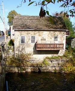 Old mill in Newburgh | |
 Stone Mills | |
| Coordinates: 44°27′N 76°55′W / 44.450°N 76.917°WCoordinates: 44°27′N 76°55′W / 44.450°N 76.917°W | |
| Country |
|
| Province |
|
| County | Lennox and Addington |
| Government | |
| • Type | Town |
| • Reeve | Eric Smith |
| • Governing Body | Corporation of the Township of Stone Mills |
| • MP | Mike Bossio |
| • MPP | Daryl Kramp |
| Area[1] | |
| • Land | 708.83 km2 (273.68 sq mi) |
| Population (2011)[1] | |
| • Total | 7,702 |
| • Density | 10.9/km2 (28/sq mi) |
| Time zone | UTC-5 (EST) |
| • Summer (DST) | UTC-4 (EDT) |
| Postal code | K0K 1N0 |
| Area code(s) | 613 |
| Website | www.stonemills.com |
Stone Mills is a lower tier township located north of Greater Napanee in Lennox and Addington County, Ontario, Canada. According to the 2011 Canadian Census, the township has a population of 7,560
Communities
The township comprises the following communities and hamlets:
- Camden East Ward: Centreville, Camden East, Colebrook, Croydon, Enterprise, Moscow, Newburgh, Yarker
- Sheffield Ward: Erinsville, Tamworth
Other minor communities such as Ballahack, Chippewa, Clareview, Curie Station, Desmond, Gull Creek, Hinch, Ingle, McGuire Settlement, Milsap, Petworth, Varty Lake and Wesley are known best by their local residents.
Centreville
Centreville (44°24′25″N 76°54′17″W / 44.40694°N 76.90472°W) is bisected by Lennox and Addington County Road 4. The Centreville Public School educates roughly 150 students in kindergarten to grade 8. A public fairgrounds, complete with a park and grandstand, showcases the annual Centreville Fair. The fair opens on the Friday of the Labour Day weekend, and closes by the next night. Centreville is also the location of the township's municipal offices.
| Climate data for Centreville | |||||||||||||
|---|---|---|---|---|---|---|---|---|---|---|---|---|---|
| Month | Jan | Feb | Mar | Apr | May | Jun | Jul | Aug | Sep | Oct | Nov | Dec | Year |
| Record high °C (°F) | 12.5 (54.5) |
12.5 (54.5) |
25.0 (77) |
30.5 (86.9) |
32.0 (89.6) |
35.0 (95) |
38.0 (100.4) |
36.0 (96.8) |
34.5 (94.1) |
27.0 (80.6) |
19.5 (67.1) |
15.5 (59.9) |
38.0 (100.4) |
| Average high °C (°F) | −3.0 (26.6) |
−1.7 (28.9) |
3.6 (38.5) |
11.9 (53.4) |
19.1 (66.4) |
24.2 (75.6) |
27.0 (80.6) |
25.8 (78.4) |
20.9 (69.6) |
13.4 (56.1) |
6.6 (43.9) |
0.1 (32.2) |
12.3 (54.1) |
| Daily mean °C (°F) | −7.7 (18.1) |
−6.9 (19.6) |
−1.5 (29.3) |
6.5 (43.7) |
13.1 (55.6) |
18.2 (64.8) |
20.9 (69.6) |
19.7 (67.5) |
15.2 (59.4) |
8.4 (47.1) |
2.5 (36.5) |
−4.1 (24.6) |
7.0 (44.6) |
| Average low °C (°F) | −12.5 (9.5) |
−12.0 (10.4) |
−6.6 (20.1) |
1.0 (33.8) |
7.0 (44.6) |
12.1 (53.8) |
14.7 (58.5) |
13.5 (56.3) |
9.4 (48.9) |
3.3 (37.9) |
−1.7 (28.9) |
−8.3 (17.1) |
1.7 (35.1) |
| Record low °C (°F) | −37.0 (−34.6) |
−31.0 (−23.8) |
−28.0 (−18.4) |
−13.5 (7.7) |
−6.5 (20.3) |
0.0 (32) |
6.0 (42.8) |
3.5 (38.3) |
−4.0 (24.8) |
−8.5 (16.7) |
−18.5 (−1.3) |
−35.5 (−31.9) |
−37.0 (−34.6) |
| Average precipitation mm (inches) | 64.2 (2.528) |
33.4 (1.315) |
65.8 (2.591) |
80.5 (3.169) |
86.4 (3.402) |
81.1 (3.193) |
63.0 (2.48) |
68.7 (2.705) |
107.9 (4.248) |
94.3 (3.713) |
100.9 (3.972) |
79.0 (3.11) |
965.6 (38.016) |
| Average rainfall mm (inches) | 38.0 (1.496) |
24.4 (0.961) |
40.0 (1.575) |
73.0 (2.874) |
86.4 (3.402) |
81.1 (3.193) |
63.0 (2.48) |
68.7 (2.705) |
107.9 (4.248) |
93.4 (3.677) |
88.9 (3.5) |
47.1 (1.854) |
811.8 (31.961) |
| Average snowfall cm (inches) | 42.6 (16.77) |
32.9 (12.95) |
25.9 (10.2) |
7.5 (2.95) |
0.1 (0.04) |
0.0 (0) |
0.0 (0) |
0.0 (0) |
0.0 (0) |
1.0 (0.39) |
12.0 (4.72) |
31.9 (12.56) |
153.8 (60.55) |
| Source: Environment Canada[2] | |||||||||||||
Croydon
Croydon (44°25′15″N 76°58′42″W / 44.42083°N 76.97833°W) is a farming community known for its friendly residents, rich history, beautiful scenery, and small-town charm. In the early and mid-1900s, Croydon was a well-developed farming community that featured several hotels, a general store, a church, a post office, a schoolhouse, and a gristmill. Although business and industry are currently non-existent in Croydon, many of the original buildings have been renovated and are serving as family homes. The main attraction is the beautiful Salmon River, which runs through the heart of Croydon. The river is used for swimming, fishing, canoeing, and kayaking.
Erinsville
Erinsville (44°29′00″N 77°03′00″W / 44.48333°N 77.05000°W) is located on Highway 41. It was founded by Irish settlers in the late 1800s. Its proximity to Beaver Lake (actually two lakes, Beaver Lake North and South) makes it an ideal summer home, and is host to several small cottage communities. The Erinsville area has both the natural beauty of forests and lakes, and is also surrounded by several family-operated farms. Largely due to its low population, Erinsville has only a few commercial business in operation. These include the Beaver Lake Variety and Gas Bar and the Lakeview Tavern and Restaurant. Several residents also run small businesses from home. Erinsville also is the site of the Church of the Assumption of the Blessed Virgin Mary, a Roman Catholic parish. A dark sky viewing area is located minutes north of Erinsville on highway 41. [3]
Newburgh
Newburgh (44°19′30″N 76°52′40″W / 44.32500°N 76.87778°W), formerly an incorporated village, retains the status of a designated place in the Canadian census data. It is situated on the Napanee River, and was first founded in 1822 by Benjamin Files and Wm. V. P. Detlor. It quickly became a thriving community and home to numerous mills. Two saw mills were first built along the river in 1822 and 1825, followed by a grist mill in 1828, two flour mills in 1840, an oatmeal mill in 1861, two carding mills and a woollen mill in 1864. Other businesses such as a tannery, two axe factories, a sash, blind and door factory, a hub and rake factory, three carriage and wagon shops and two cabinet factories were also established.
By 1865, Newburgh had a population of 1,200, but that population quickly declined. Railway lines bypassed the village and manufacturers were unable to move goods efficiently to and from Newburgh. The village did not get the Napanee, Tamworth and Quebec Railway line until 1884. Also, contributing to this decline were several major fires, the worst which happened in 1887 and destroyed eighty-four buildings in the centre of the village.
Today Newburgh is thriving with the Newburgh Clinic run by two doctors, Newburgh Public School and Newburgh Post Office, Newburgh United Church, Newburgh Pharmacy, Newburgh L.C.B.O., a small grocery store and a gas station, Newburgh Abram's Bakery, Second Time Treasures by Louise, Clarke Art and Projects art gallery, and Rogues' Hollow Antiques, Ontario's two largest chicken farms, and numerous small businesses such as barber shops and hair salons.
In the Canada 2011 Census, Newburgh had a population of 696, down from 725 in the 2006 census.[4]
Tamworth
Tamworth (44°29′15″N 76°59′40″W / 44.48750°N 76.99444°W) Originally settled in 1826, Tamworth received its name in 1848, the year of the great potato famine in Ireland. The area was settled by many Irish immigrants and by 1865 the population of the area was 500. In 1884 the Tamworth and Quebec Railway had three trains departing to Napanee each day. Once the forest cover had been removed the soil that remained was not of the best quality, but farmers persevered and the area included many cheese factories. Farmers could supplement their incomes cutting trees in winter to be floated down the Napanee River to mills to the south. Featured in Michael Ondaatje’s “In the Skin of Lion” Tamworth is a charming village steeped in the history of the hard work of the generations who laboured to create a life here.
Tamworth today is a mix of farms, homes and cottages on Beaver Lake and includes all the services of a more populated city with the charm of a village. Churches, a bank, hockey arena, a video store, restaurants, a hardware store, grocery store, pharmacy, liquor store, library and many other amenities, make for a great place to raise a family. Beaver Lake flows into the Salmon River which runs through Tamworth and this flowing water was the source of much of the commerce in the mills that form part of Tamworth’s past.
Tamworth is home to the first Irish Language speaking area, or Gaeltacht, to be announced outside Ireland. This is an important symbol of hope for the struggling minority language. See main article Permanent North American Gaeltacht. Tamworth had a Senior A amateur team from 2003 to 2005. The Braves played in the Eastern Ontario Senior Hockey League. A Tier II Junior "A" team operated in 2007-2009 known as the Tamworth Cyclones in the Greater Metro Junior A Hockey League. Tamworth is the largest community in the former Sheffield Township of less than 1600 people .
Demographics
| Canada census – Stone Mills community profile | |||
|---|---|---|---|
| 2011 | 2006 | ||
| Population: | 7560 (-0.1% from 2006) | 7568 (3.1% from 2001) | |
| Land area: | 708.83 km2 (273.68 sq mi) | 688.28 km2 (265.75 sq mi) | |
| Population density: | 10.7/km2 (28/sq mi) | 11.0/km2 (28/sq mi) | |
| Median age: | 41.0 (M: 41.0, F: 40.9) | ||
| Total private dwellings: | 3169 | 3122 | |
| Median household income: | $59,615 | ||
| References: 2011[5] 2006[6] earlier[7] | |||
Notable people
- Hammel Madden Deroche, an Ontario lawyer and political figure from Newburgh.
- Manly Benson, a Methodist minister and lecturer from Newburgh.
- Robert Fulford Ruttan, a chemist, university professor and administrator from Newburgh.
- Weston Price, a famous dentist, nutritionist, and author from Newburgh.
- Sir Allen Bristol Aylesworth, minister or labour, minister of justice and Canadian senator from Newburgh.
- Samuel Sobieski Nelles, principal of Newburgh Academy for one year.
- Bob Casey (third baseman) "Casey at Bat"
See also
References
- 1 2 "Stone Mills census profile". 2011 Census of Population. Statistics Canada. Retrieved 2012-02-13.
- ↑ "Centreville". Canadian Climate Normals 1981–2010 (in English and French). Environment Canada. Retrieved September 17, 2015.
- ↑ Dark Sky Viewing Area, - Lennox and Addington
- ↑ "Newburgh, Ontario census profile". 2011 Census of Population. Statistics Canada. Retrieved 2012-02-17.
- ↑ "2011 Community Profiles". Canada 2011 Census. Statistics Canada. July 5, 2013. Retrieved 2012-02-13.
- ↑ "2006 Community Profiles". Canada 2006 Census. Statistics Canada. March 30, 2011. Retrieved 2012-02-13.
- ↑ "2001 Community Profiles". Canada 2001 Census. Statistics Canada. February 17, 2012.
External links
Places adjacent to Stone Mills | |
|---|---|