Eridge Park
| Site of Special Scientific Interest | |
 | |
 Location within East Sussex | |
| Area of Search | East Sussex |
|---|---|
| Grid reference | TQ576344 |
| Coordinates | 51°05′13″N 0°15′04″E / 51.087°N 0.251°ECoordinates: 51°05′13″N 0°15′04″E / 51.087°N 0.251°E |
| Interest | Biological |
| Area | 390.1 ha (964 acres) |
| Notification | 1966 |
| Natural England website | |
Eridge Park (/ˈɛrɪdʒ/) occupies the north of the parish of Rotherfield. Its adjoining home of the same name is the seat of the Marquess of Abergavenny.
The name Eridge derives from 'Eagle ridge', or 'ridge frequented by eagles'.[1]
Location
Eridge Park is directly north of Rotherfield, and largely overlaps the ecclesiastical parish of Eridge Green. Eridge Castle, the predecessor property, until 1856 had its own ecclesiastical parish.[2]
House and park
Eridge was the seat (main home) of the Earls and Marquesses of Abergavenny.[2] In 1792 Henry Nevill, 2nd Earl of Abergavenny converted the old Eridge House into a Gothic castle, which he named Eridge Castle. The castle was replaced by a neo-Georgian mansion in the 1930s. As a 20th-century structure on an ancient site, the house is not a listed building.
The undulating park and garden of Eridge Park is densely wooded to its north (Whitehill Wood) and south (Saxonbury Hill),[3] and is highly rated (Grade II* listed) for its landscape by English Heritage.[4]
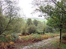
The park itself has substantial dense woodland to north and south, forming a Site of Special Scientific Interest in East Sussex, England.[5] The parkland is of biological interest, consisting of ancient woodland and parkland, supporting a wide range of flora and fauna. Its particular scientific uniqueness is that is the best site in Great Britain for epiphytic lichen.
Village and surroundings
On the village street is the church, which is Grade II listed,[6] and six other listed buildings including the public house, the Nevill Crest and Gun.
The area also contains several follies, including the Saxonbury Tower and several ornamental buildings near the Sham Farm industrial estate. Sham Farm, an arable farm, gets its name from a wall built there to hide imposing farm buildings, which was intended to make the farm look like a very large house when viewed from Eridge Castle.[7] The industrial estate at Sham Farm includes businesses such as Chalybeate Springs Trout Fishery and the Speldhurst Quality Foods sausage factory.[8][9]
References
- ↑ Glover, Judith (1975). The Place Names of Sussex. London: B.T. Batsford Ltd. p. 53. ISBN 0-7134-2853-8.
- 1 2 Nevill Estate Company Ltd. "History". Eridge Park. Archived from the original on 2017-10-02.
- ↑ "Grid square map". Ordnance Survey. UK.
- ↑ Eridge Park (Park and Garden), Historic England. "Details from listed building database (1000265)". National Heritage List for England. Retrieved 26 August 2013.
- ↑ "SSSI Citation — Eridge Park" (PDF). Natural England. Archived from the original (PDF) on 20 March 2009. Retrieved 2 November 2008.
- ↑ Holy Trinity Church, Eridge, Grade II, Historic England. "Details from listed building database (1028329)". National Heritage List for England. Retrieved 26 August 2013.
- ↑ BBC (1986). "Sham Farm". Domesday Reloaded. Archived from the original on 9 June 2016.
- ↑ "Chalybeate Springs Trout Fishery" (official website).
- ↑ "Our Story". Speldhurst Quality Foods.
External links
- "Nap Wood" (PDF). National Trust. Archived from the original on 2011-08-12.
- Willoughby, Leonard (1907). "Deer-taking at Eridge Park". The Badminton Magazine of Sports and Pastimes. Vol. XXIV no. CXXXIX. pp. 183–196.