Erbendorf
| Erbendorf | ||
|---|---|---|
| ||
 Erbendorf Location of Erbendorf within Tirschenreuth district 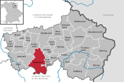 | ||
| Coordinates: 49°50′N 12°3′E / 49.833°N 12.050°ECoordinates: 49°50′N 12°3′E / 49.833°N 12.050°E | ||
| Country | Germany | |
| State | Bavaria | |
| Admin. region | Oberpfalz | |
| District | Tirschenreuth | |
| Government | ||
| • Mayor | Hans Donko (CSU) | |
| Area | ||
| • Total | 67.55 km2 (26.08 sq mi) | |
| Elevation | 506 m (1,660 ft) | |
| Population (2017-12-31)[1] | ||
| • Total | 5,097 | |
| • Density | 75/km2 (200/sq mi) | |
| Time zone | CET/CEST (UTC+1/+2) | |
| Postal codes | 92681 | |
| Dialling codes | 09682 | |
| Vehicle registration | TIR | |
| Website | www.erbendorf.de | |

Erbendorf is a town in the Upper Palatinate (Oberpfalz) region of Germany. As of December, 2006, the town has a population of 5,341.
The following villages are incorporated into the town: Aschenhof, Birkenreuth, Boxdorf, Eppenhof, Frodersreuth, Glashütte, Gössenreuth, Gramlhof, Grötschenreuth, Hauxdorf, Inglashof, Napfberg, Neuenreuth, Pfaben, Plärn, Schadenreuth, Siegritz, Steinbach, Straßenschacht, Thann, Wäldern, Wetzldorf, and Wildenreuth.
Main Attractions of Erbendorf
- Hiking and biking in the Stienwald region; a mountain range and a national park well known for its long-distance trials.
- The Mining Museum of Erbendorf, as the city has a very rich mining history.
- A public recreation center equipped with two heated outdoor pools.
Sons and daughters of the city
- Hans Müller (1898-1974), politician (SPD), Member of Bundestag 1953-1965
- Wilhelm Schraml (born 1935), 84. Bishop of Passau
Personalities who have worked in the city
- Norbert Scharf (1952-2010), Landtag deputy (SPD), was from 2005 to 2008 member of the town council of Erbendorf
References
- ↑ "Fortschreibung des Bevölkerungsstandes". Bayerisches Landesamt für Statistik und Datenverarbeitung (in German). September 2018.
External links
Towns and municipalities in Tirschenreuth (district) | ||
|---|---|---|
This article is issued from
Wikipedia.
The text is licensed under Creative Commons - Attribution - Sharealike.
Additional terms may apply for the media files.