Eptalofos, Phocis
| Eptalofos Επτάλοφος | |
|---|---|
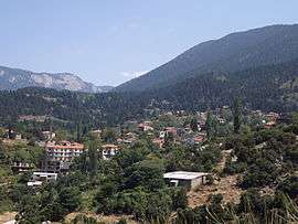 A view of Eptalofos | |
 Eptalofos | |
| Coordinates: 38°35.62632′N 22°29.68878′E / 38.59377200°N 22.49481300°ECoordinates: 38°35.62632′N 22°29.68878′E / 38.59377200°N 22.49481300°E | |
| Country | Greece |
| Administrative region | Central Greece |
| Regional unit | Phocis |
| Municipality | Delphi |
| Municipal unit | Parnassos |
| Elevation | 832 m (2,730 ft) |
| Population (2011)[1] | |
| • Rural | 461 |
| Community[1] | |
| • Population | 470 (2011) |
| • Area (km2) | 32.796 |
| Time zone | UTC+2 (EET) |
| • Summer (DST) | UTC+3 (EEST) |
| Postal code | 330 57 |
| Area code(s) | +30-2234-xxx-xxx |
| Vehicle registration | ΑΜx-xxxx |
Eptalofos (Greek: Επτάλοφος) is a village and a community of the Delphi municipality.[1] Before the 2011 local government reform it was a part of the municipality of Parnassos, of which it was a municipal district.[2] The 2011 census recorded 461 residents in the village and 470 residents in the community.[1] The community of Eptalofos covers an area of 32.796 km2.[3]
Administrative division
The community of Eptalofos consists of four separate settlements:[1]
- Alataries (population 4)
- Eptalofos (population 461)
- Itamos (uninhabited)
- Zampeios (population 5)
The aforementioned population figures are as of 2011.[1]
Population
According to the 2011 census, the population of the settlement of Eptalofos was 461 people, an increase of almost 14% compared to the previous census of 2001.[1][3]
|
See also
References
- 1 2 3 4 5 6 7 8 "Απογραφή Πληθυσμού - Κατοικιών 2011. ΜΟΝΙΜΟΣ Πληθυσμός" (in Greek). Hellenic Statistical Authority.
- ↑ Kallikratis law Greece Ministry of Interior (in Greek)
- 1 2 3 "Population & housing census 2001 (incl. area and average elevation)" (PDF) (in Greek). National Statistical Service of Greece. Archived from the original (PDF) on 2015-09-21.
This article is issued from
Wikipedia.
The text is licensed under Creative Commons - Attribution - Sharealike.
Additional terms may apply for the media files.