Entella (river)
| Entella | |
|---|---|
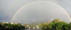 Rainbow on the Entella near its mouth | |
 | |
| Country | Italy |
| Physical characteristics | |
| Main source |
Carasco 30 m (98 ft) |
| River mouth |
Ligurian Sea between Chiavari and Lavagna 0 m (0 ft) |
| Length | around 6 km (3.7 mi)[1] |
| Discharge | |
| Basin features | |
| Basin size | 376 km2 (145 sq mi)[4] |
The Entella is a very short river within the Metropolitan City of Genoa (former Province of Genoa) in the Liguria region of northwestern Italy.
It and its tributaries flow from the Ligurian Apennines Mountains to the Ligurian Sea.
Etymology
The name Entella was given to the river by Ptolemy; it's maybe derived from entos ( = inside) and elòa ( = olive), due to the dark-green colour of the river banks of its upper basin. The name came into the popular use from the end of the 18th century; the river was previously called by common people Lavagna.[5]
In 1914 the football club Foot-Ball Club Entella (now Virtus Entella) took its name from the river.[6]
Geography
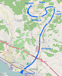
The Entella is formed by the confluence of the Lavagna and Sturla streams, near Carasco in the Province of Genova. The river then flows westwards at first before turning south before it meets the Ligurian Sea between Chiavari and Lavagna, in a large and in summer an almost totally dry riverbed.
Tributaries
Besides Lavagna and Sturla the only relevant tributary of the Entella river is the torrente Graveglia.[2]
History
The Département de l'Entelle or Dipartimento dell'Entella of Ligurian Republic took its name at the end of the 18th century from the river.[7]
Conservation
The medium and low part of the river course belongs to the SIC (Site of Community Importance) called Foce e medio corso del Fiume Entella - code IT1332717.[8]
References
- ↑ Giuseppe Valle (2015-03-14). "Chiavari: petizione per salvare il fiume Entella". Levante news. Retrieved May 11, 2015.
- 1 2 AA.VV. "IL BACINO DEL FIUME ENTELLA" (PDF). cartogis.provincia.genova.it. Provincia di Genova. Archived from the original (PDF) on May 18, 2015. Retrieved May 11, 2015.
- ↑ 13.875 m3/s (490.0 cu ft/s) is an esteem of the real discharge; natural discharge (also considering artificial water derivations) = 14.53 m3/s (513 cu ft/s)
- ↑ AA.VV. "CARATTERISTICHE ACQUE COSTIERE: scheda 19" (PDF). www.cartografiarl.regione.liguria.it. Regione Liguria. Archived from the original (PDF) on May 18, 2015. Retrieved May 11, 2015.
- ↑ Casini, A. "Storia di Lavagna". www.turismolavagna.altervista.org. Città di Lavagna. Retrieved May 11, 2015.
- ↑ Aldo Pio Feoli (2014-11-29). "I Diavoli Neri nell'inferno del Comunale: per l'Entella è la prima in Serie B". www.ilciriaco.it. Retrieved May 11, 2015.
- ↑ Gazzetta universale (in Italian). 1797. Retrieved November 4, 2015.
- ↑ "Foce e medio corso del Fiume Entella" (PDF) (in Italian). Regione Liguria. Retrieved 2018-03-12.
See also
- Drainage basins of the Ligurian Sea
- Rivers of the Metropolitan City of Genoa (Province of Genoa)
- List of rivers of Italy
External links
| Wikimedia Commons has media related to Entella river. |