Englevale, North Dakota
| Englevale, North Dakota | |
|---|---|
| Census-designated place & Unincorporated community | |
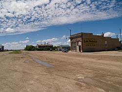 Buildings in Englevale | |
 Englevale, North Dakota | |
| Coordinates: 46°23′34″N 97°54′48″W / 46.39278°N 97.91333°WCoordinates: 46°23′34″N 97°54′48″W / 46.39278°N 97.91333°W | |
| Country | United States |
| State | North Dakota |
| County | Ransom |
| Area[1] | |
| • Total | 1.486 sq mi (3.85 km2) |
| • Land | 1.486 sq mi (3.85 km2) |
| • Water | 0 sq mi (0 km2) |
| Elevation | 1,345 ft (410 m) |
| Population (2010)[2] | |
| • Total | 40 |
| • Density | 27/sq mi (10/km2) |
| Time zone | UTC-6 (Central (CST)) |
| • Summer (DST) | UTC-5 (CDT) |
| Area code(s) | 701 |
| GNIS feature ID | 1028890[3] |
Englevale is a census-designated place and unincorporated community in Ransom County, North Dakota, United States. Its population was 40 as of the 2010 census.[2] The community was initially named Marshall after landowner Marshall T. Davis; it was later renamed for Mathias L. Engel, a promoter for the community.[3]
References
- ↑ "US Gazetteer files: 2010, 2000, and 1990". United States Census Bureau. 2011-02-12. Retrieved 2011-04-23.
- 1 2 "American FactFinder". United States Census Bureau. Archived from the original on 2013-09-11. Retrieved 2011-05-14.
- 1 2 "Englevale". Geographic Names Information System. United States Geological Survey.
Municipalities and communities of Ransom County, North Dakota, United States | ||
|---|---|---|
| Cities | 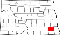 | |
| Townships |
| |
| CDPs | ||
| Unincorporated community |
| |
| Footnotes | ‡This populated place also has portions in an adjacent county or counties | |
This article is issued from
Wikipedia.
The text is licensed under Creative Commons - Attribution - Sharealike.
Additional terms may apply for the media files.