En-route chart
In aviation, an en-route chart is an aeronautical chart that guides pilots flying under instrument flight rules (IFR) during the en-route phase of flight.
Overview
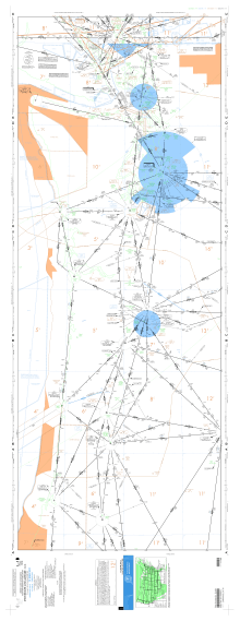
An en-route (also known as en route[1] or enroute[2]) chart provides detailed information useful for instrument flight, including information on radionavigation aids (navaids) such as VORs and NDBs, navigational fixes (waypoints and intersections), standard airways, airport locations, minimum altitudes, and so on. Information not directly relevant to instrument navigation, such as visual landmarks and terrain features, is not included.
En-route charts are divided into high and low versions, with information on airways and navaids for high- and low-altitude flight, respectively. The division between low altitude and high altitude is usually defined as the altitude that marks transition to flight levels (in the United States, this is taken to be 18,000 feet MSL by convention).
References
- ↑ "En Route Charts (ERC)". raafais.gov.au. Australia: RAAF Aeronautical Information Service. Retrieved 2015-08-24.
- ↑ "IFR Enroute Aeronautical Charts and Planning". faa.gov. United States: Federal Aviation Administration. Retrieved 2015-08-24.
External links
