Emu Flat, Victoria
| Emu Flat Victoria | |
|---|---|
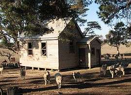 Former Emu Flat State School | |
 Emu Flat | |
| Coordinates | 37°05′S 144°45′E / 37.083°S 144.750°ECoordinates: 37°05′S 144°45′E / 37.083°S 144.750°E |
| Postcode(s) | 3522.[1] |
| Location |
|
| LGA(s) | Shire of Mitchell |
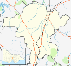
Emu Flat is a locality in the Shire of Mitchell local government area, in Victoria, Australia. It is situated between Lancefield and Tooborac, 92 kilometres to the north-west of Melbourne by road.[2][3]
Emu Flat has two "heritage places" listed in the Shire of Mitchell Planning Scheme. These are the Uniting Church (formerly Presbyterian Church), and the former State School.[4]
The Emu Flat Post Office opened on 17 September 1877 and closed in 1945.[5]
References
- ↑ "Location:Emu Flat, Vic". Postcode Search. Australia Post. Retrieved 2008-04-21.
- ↑ "travelmate.com.au". Archived from the original on 2007-03-25. Retrieved 2008-04-21. (Emu Flat-Baynton Rd, Nulla Vale )
- ↑ "Emu Flat". Place Names Search. Geoscience Australia. Retrieved 2008-04-21.
- ↑ "Schedule to the Heritage Overlay". Mitchell Planning Scheme. Retrieved 2008-04-21.
- ↑ Premier Postal History. "Post Office List". Retrieved 2008-04-11.
External links
![]()
This article is issued from
Wikipedia.
The text is licensed under Creative Commons - Attribution - Sharealike.
Additional terms may apply for the media files.