Elst, Gelderland
| Elst | |||
|---|---|---|---|
| |||
| Coordinates: 51°54′56″N 5°50′16″E / 51.91556°N 5.83778°E | |||
| Country | Netherlands | ||
| Province | Gelderland | ||
| Municipality | Overbetuwe | ||
| Population (2012) | 21.447[1] | ||


Elst is a city in the municipality of Overbetuwe in the Dutch province of Gelderland. It is situated in the Betuwe, between the cities of Nijmegen and Arnhem. Elst has 21,447 inhabitants.[1]
Elst is known for its Roman temples, which are situated under the Saint Werenfried church. Elst was a separate municipality until 2001, when it became a part of Overbetuwe.[2]
H. J. Heinz Company's sauce factory for the European market is located south of the town centre.
Elstar is an apple cultivar that was developed in Elst in the 1950s.
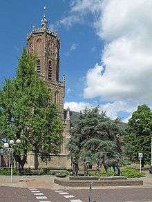
Saint-Martin Church in Elst
Education
Elst is home to three high schools: Het Westeraam, Lyceum and Over Betuwe College Elst (OBC Elst).
Sports
There are several sports clubs in Elst, including:
- Spero (Football)
- BCE (badminton)
- Elistha (Football)
- ETV (tennis)
- EZ & PC (swimming)
- Gaviiformes (scuba diving)
- Gemini (Volleyball)
- HCOB (field hockey)
- Unlimited (basketball)
- Budo vereniging (martial arts)
People born in Elst
- Frits Kuipers (1899–1943), footballer
- Pierre Kartner (born 1935), singer and composer
- Paul Kuypers (1939–1971), agricultural scientist
- Jeffrey Leiwakabessy (born 1981), footballer
- Jasper Rennspies (1930-1950), footballer
- Peter Tijssen (born 1944 (Elden)), virology professor (University of Quebec), recipient highest award for foreign experts in China
- Henk "Henkie" Leeuwis (born 1946), singer
- Peter J. Williamson (born 1823), architect (Vanderbilt University), American Civil War adjutant to General William T. Sherman
- Jan Zwartkruis (1925-2013), footballer
- Anna van Rooijen (born 2001), famous didgeridoo player
- Gijs Peters (born 2001), pizza chef
Transportation
References
- 1 2 overbetuwe.nl Archived 2015-09-24 at the Wayback Machine.
- ↑ Ad van der Meer and Onno Boonstra, Repertorium van Nederlandse gemeenten, KNAW, 2006.
External links
- J. Kuyper, Gemeente Atlas van Nederland, 1865-1870, "Elst". Map of the former municipality, around 1868.
Coordinates: 51°54′56″N 5°50′16″E / 51.91556°N 5.83778°E
This article is issued from
Wikipedia.
The text is licensed under Creative Commons - Attribution - Sharealike.
Additional terms may apply for the media files.