Elst, Utrecht
| Elst | |
|---|---|
| Town | |
.jpg) View of Elst from the other side of the Lower Rhine. | |
 | |
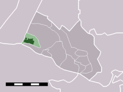 Elst in the municipality of Rhenen. | |
| Coordinates: 51°59′8″N 5°29′55″E / 51.98556°N 5.49861°ECoordinates: 51°59′8″N 5°29′55″E / 51.98556°N 5.49861°E | |
| Country | Netherlands |
| Province | Utrecht |
| Municipality | Rhenen |
| Population (2004) | |
| • Total | 4,220 |
| Time zone | UTC+1 (CET) |
| • Summer (DST) | UTC+2 (CEST) |
| Postal code | 3921 |
| Dialing code | 0318 |
Elst is a town in the central Netherlands. It is located in the municipality of Rhenen, Utrecht, about 5 km southwest of Veenendaal.
In 2001, the town of Elst had 3008 inhabitants. The built-up area of the town was 0.56 km², and contained 1130 residences.[1]
Until 1 January 2006, the western tip of the village was in the municipality of Amerongen (see map on the right).
References
- ↑ Statistics Netherlands (CBS), Bevolkingskernen in Nederland 2001 . Statistics are for the continuous built-up area.
.jpg)
Ferry on Rhine, near Elst
This article is issued from
Wikipedia.
The text is licensed under Creative Commons - Attribution - Sharealike.
Additional terms may apply for the media files.