Elsie, Oregon
| Elsie, Oregon | |
|---|---|
| Unincorporated community | |
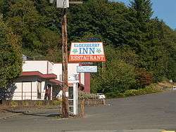 Elderberry Inn | |
 Elsie Location within the state of Oregon  Elsie Elsie (the US) | |
| Coordinates: 45°51′56″N 123°35′41″W / 45.86556°N 123.59472°WCoordinates: 45°51′56″N 123°35′41″W / 45.86556°N 123.59472°W | |
| Country | United States |
| State | Oregon |
| County | Clatsop |
| Elevation | 453 ft (138 m) |
| Time zone | UTC-8 (Pacific (PST)) |
| • Summer (DST) | UTC-7 (PDT) |
| ZIP code | 97138 |
| Area code(s) | 503 and 971 |
| GNIS feature ID | 1136261[1] |
Elsie is an unincorporated community in Clatsop County, Oregon, United States. It is located in the Northern Oregon Coast Range, west of the junction of Oregon Route 103 and U.S. Route 26 where the roads cross the Nehalem River.
Elsie was named after Elsie Foster, who was a relative of George Gragg, the first postmaster.[2] Elsie post office was established in 1892 and closed in 1943.[2]
Camp 18 is a restaurant and logging museum in Elsie.[3] The restaurant is built in the style of a log cabin, using local timber.[3] The building includes an 85-foot ridge pole and front doors that weigh 500 pounds each.[3]
References
- ↑ "Elsie, Oregon". Geographic Names Information System. United States Geological Survey.
- 1 2 McArthur, Lewis A.; Lewis L. McArthur (2003) [1928]. Oregon Geographic Names (7th ed.). Portland, Oregon: Oregon Historical Society Press. p. 328. ISBN 0-87595-277-1.
- 1 2 3 Camp 18 Logging Museum & Restaurant History
External links
![]()
- Photo of the confluence of West and East Humbug creeks at Elsie by Ian Sane
- Elsie history from VanNatta Brothers Logging
- Article about Camp 18 from Via, the AAA magazine
Municipalities and communities of Clatsop County, Oregon, United States | ||
|---|---|---|
| Cities |  | |
| CDPs | ||
| Other unincorporated communities | ||
This article is issued from
Wikipedia.
The text is licensed under Creative Commons - Attribution - Sharealike.
Additional terms may apply for the media files.