Elie, Manitoba
| Elie | |
|---|---|
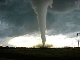 Canada's first F5 Tornado approaching Elie in June 2007 | |
 Elie Location of Elie, Manitoba | |
| Coordinates: 49°54′06″N 97°45′29″W / 49.90167°N 97.75806°WCoordinates: 49°54′06″N 97°45′29″W / 49.90167°N 97.75806°W | |
| Country |
|
| Province |
|
| Elevation | 400 m (1,300 ft) |
| Population (2011)[1] | |
| • Total | 550 |
| Time zone | UTC−5 (CST) |
| Postal code | R0H 0H0 |
| Area code(s) | 204, 431 |
Elie /ˈiːlaɪ/ is an unincorporated community recognized as a local urban district[2] in the Rural Municipality of Cartier in the Canadian province of Manitoba.
Geography
The community is located approximately 30 km (19 mi) west of Winnipeg along the Trans-Canada Highway. The Assiniboine River forms the northern boundary of the municipality of Cartier. Other significant communities around Elie include St. Eustache, Dacotah and Springstein.
History
June 2007 tornado
On June 22, 2007, Elie was hit by an F5 tornado, the most powerful ever recorded in Canada, which damaged a flour mill and destroyed several houses, ripping two well-built houses off their foundations. A car was also thrown 100 metres (330 ft), but the tornado only caused one injury and no deaths, as the people had an early warning which provided them with enough time to look for protection. Warnings were provided by Environment Canada.
Economy
The primary industry of Elie is agriculture. The CHMI-DT Transmitter was constructed in 1986 and is located here.
References
- ↑ 2011 Community Profiles - Census Subdivision
- ↑ "Local Urban Districts Regulation". Government of Manitoba. April 23, 2016. Retrieved April 24, 2016.
External links
![]()
Division No. 10, Manitoba (Whitehorse Plains) | ||
|---|---|---|
| Rural municipalities | 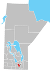 | |
| Unincorporated communities | ||