Illinois Route 390
| ||||
|---|---|---|---|---|
| Elgin–O'Hare Tollway | ||||
 | ||||
| Route information | ||||
| Maintained by ISTHA | ||||
| Length | 9.8 mi[1] (15.8 km) | |||
| Existed | October 29, 2013[2] – present | |||
| Major junctions | ||||
| West end |
| |||
| ||||
| East end |
| |||
| Location | ||||
| Counties | DuPage, Cook | |||
| Highway system | ||||
| ||||

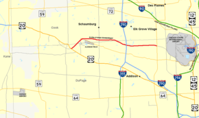
Illinois Route 390 (IL 390), previously known as the Elgin–O'Hare Expressway, now known as the Elgin–O'Hare Tollway, is an electronic toll highway in northeastern Illinois. IL 390 currently connects U.S. Route 20 (US 20, Lake Street) in Hanover Park to the intersection with Illinois Route 83 (IL 83) and Thorndale Avenue in Wood Dale. The only other towns it borders are Schaumburg and Roselle. IL 390 is 9.8 miles (15.77 km) long. Construction is underway to extend the road from IL 83 to the western edge of O'Hare International Airport.
Route description
IL 390 begins at an interchange with US 20 in Hanover Park and branches off northeastward as a three-lane toll road, traveling over a half-mile-long (0.8 km) bridge over the Metra Milwaukee District West Line tracks, and some wetlands. The highway then enters Cook County from DuPage County and intersects IL 19 (Irving Park Road). At Meacham Road, the highway crosses back south into DuPage County. Continuing east for five miles (8.0 km), IL 390 traverses portions of the suburbs of Schaumburg, Roselle, Medinah, Elk Grove Village, and then intersects with IL 53 before a major interchange with I-290 in Itasca. IL 390 continues east for four miles (6.4 km) through Wood Dale, Elk Grove Village (again), and Bensenville, and finally ends at an intersection with IL 83 in Bensenville just short of the west side of O'Hare International Airport. IL 390 is the first route in the state to have all-electronic toll collection; cash is not accepted, and an I-Pass is required.
History
| |
|---|---|
| Location | Hanover Park–Itasca |
| Length | 5.95 mi[1] (9.58 km) |
| Existed | November 2, 1993[2]–October 29, 2013[3] |
Although the concept of an Elgin–O'Hare Expressway dates back to the 1960s, the highway was not seriously considered until the late 1980s. Around that time, congestion was rapidly increasing on local roads, especially US 20 (Lake Street). Although Lake Street was extensively widened prior to the completion of the highway, initially to Glen Ellyn Road and then to the Roselle-Bloomingdale border nearly ten years later, its capacity was still insufficient for the rapidly growing western suburbs. Construction on the highway began around 1991 and was completed two years later. Governor Jim Edgar opened the highway at an afternoon ceremony on November 2, 1993.[2]
When the highway first opened, both of its termini had traffic signals with major arterial roads in the area. This arrangement caused large backups during weekday rush hours. According to the Illinois Department of Transportation (IDOT), average daily traffic counts (in 2003) for IL 390 are 39,600 vehicles for the western two miles (3.2 km) and around 82,000 to 87,000 cars per day for the remainder.[4]
On October 29, 2013, IDOT announced that the highway was re-designated IL 390 at groundbreaking ceremonies for the Elgin–O’Hare Western Access Project.[3] Shortly after, maintenance of the road was transferred to the Illinois State Toll Highway Authority (ISHTA), and toll collection on the existing segment from US 20 in Hanover Park to I-290 in Itasca began in 2016.[5] The ISHTA began constructing an eastward extension of IL 390 to a new interchange on the western border of O'Hare International Airport with the planned I-490 connecting I-90 to the north and I-294 to the south.[6][7] This interchange may also incorporate ramps into a planned western terminal at O'Hare. The official groundbreaking for the expansion took place on October 29, 2013.[3] The first four miles (6.4 km) segment of this extension, opened at a ribbon-cutting ceremony on November 1, 2017, stretching from the upgraded interchange with I-290 in Itasca to IL 83 in Bensenville.[8] East of I-290, IL 390 was formerly a four-lane arterial at-grade road known as Thorndale Avenue until its upgrade into an extension of IL 390, along with the interchange with I-290. Thorndale Avenue ran from I-290 to York Road near the western border of O'Hare International Airport. After its upgrade, the Thorndale Avenue designation was assigned to the new frontage roads along both sides of the eastern extension of IL 390.
Future
The remaining section of IL 390 from IL 83 in Bensenville to the western edge of O'Hare International Airport is currently under construction and is expected to open in 2019. As of 2016, a feasibility study is underway on the western extension of IL 390 from US 20 to North Avenue, as well as improvements to US 20 between North Avenue and Shales Parkway.[9] However, unlike the original plans, the entire extension is proposed to be an arterial road rather than a limited access freeway or tollway.
Exit list
| County | Location[1] | mi[10] | km | Exit | Destinations | Notes |
|---|---|---|---|---|---|---|
| DuPage | Hanover Park | 6.0 | 9.7 | Partially built interchange; current western terminus of the Elgin-O'Hare Tollway | ||
| 6.6 | 10.6 | Lake Street Toll Plaza | ||||
| Cook | Schaumburg | 7.1 | 11.4 | Eastbound exit is located here | ||
| Roselle | 7.4 | 11.9 | 7B | Westbound exit, eastbound entrance; flyover ramp to southbound Gary Avenue | ||
| Schaumburg | 7.7 | 12.4 | 7A | Westbound exit is located here | ||
| 8.3 | 13.4 | 8 | Rodenburg Road, Wright Boulevard | Westbound exit to North Frontage Road, which accesses both streets and eventually IL 19; eastbound, South Frontage Road terminates and joins with the Elgin O'Hare Expressway | ||
| 8.8 | 14.2 | Mitchell Boulevard Toll Plaza | ||||
| Roselle | 9.4 | 15.1 | 9 | Roselle Road | Full diamond interchange | |
| 10.6 | 17.1 | Plum Grove Road Toll Plaza | ||||
| DuPage | Itasca | 11.2 | 18.0 | 11 | Meacham Road | Medinah Road southbound, Meacham Road northbound; westbound exit to a left-lane turnaround ramp leading to ramp for IL 53; westbound separate exit to IL 53 westbound exit 12A |
| Elk Grove Village | 12.5 | 20.1 | 12 | Signed as exits 12B and 12C westbound | ||
| 12.9 | 20.8 | Park Boulevard | Eastbound exit only from I-290; westbound entrance; westbound entrance I-Pass only | |||
| 13.1 | 21.1 | Hamilton Lakes Boulevard Toll Plaza | ||||
| 13.8 | 22.2 | 13 | ||||
| Wood Dale | 14.3 | 23.0 | Mittel Drive Toll Plaza | |||
| 14.8 | 23.8 | 14 | ||||
| 15.3 | 24.6 | Lively Boulevard Toll Plaza | ||||
| Bensenville | 15.8 | 25.4 | Eastbound exit and westbound entrance; full-access interchange expected to be completed in 2019 | |||
| Interchange scheduled to open in 2019 | ||||||
1.000 mi = 1.609 km; 1.000 km = 0.621 mi
| ||||||
References
- 1 2 3 Illinois Technology Transfer Center (2007). "T2 GIS Data". Illinois Department of Transportation. Retrieved January 3, 2009.
- 1 2 3 Ibata, David (November 3, 1993). "Gridlock Bandage: Elgin-O'Hare Expressway—at Least Part of It—Opens". Chicago Tribune.
- 1 2 3 "Governor Quinn and Local Leaders Break Ground on $3.4 Billion Elgin O'Hare Western Access Project: New Illinois Route 390 is First Part of the State's Largest Roadway Project and Will Create Thousands of Jobs" (Press release). State of Illinois. October 29, 2013. Retrieved October 29, 2013.
- ↑ Illinois Department of Transportation (2006). "Getting Around Illinois". Illinois Department of Transportation. Archived from the original on February 19, 2007. Retrieved March 3, 2007.
- ↑ Illinois State Toll Highway Authority. "EOWA Project Update". Illinois State Toll Highway Authority. Retrieved January 10, 2017.
- ↑ Rice, Jennifer (January 17, 2013). "Elgin–O'Hare access approved for construction". The Fox Valley Labor News. Retrieved January 3, 2013.
- ↑ Illinois State Toll Highway Authority. "EOWA Corridor Overview". Illinois State Toll Highway Authority. Archived from the original on September 24, 2015. Retrieved September 20, 2015.
- ↑ "Illinois Tollway Delivers New Illinois Route 390 Tollway". CBS Chicago. Chicago: WBBM-TV. Retrieved January 15, 2018.
- ↑ "US 20 Feasibility Study: Shales Parkway to IL-390/IL-390 Western Extension". Retrieved February 23, 2016.
- ↑ Illinois State Toll Highway Authority (2018). Illinois Virtual Tollway (Map). Illinois State Toll Highway Authority. Retrieved February 17, 2018.
External links
Route map:
- Official website
- Illinois Highway Ends: Elgin-O'Hare Expressway
- Airport Planning & O'Hare Airport (DuPage County)
- O'Hare International Airport Master Plan
| Authority control |
|---|