Electoral district of Wimmera (Victorian Legislative Council)
| Wimmera Victoria—Legislative Council | |
|---|---|
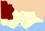 Location in Victoria | |
| State | Victoria |
| Created | 1851 |
| Abolished | 1856 |
| Namesake | Wimmera (region) |
| Demographic | Rural |
The Electoral district of Wimmera was one of the original sixteen electoral districts[1] of the old unicameral Victorian Legislative Council of 1851 to 1856. Victoria being a colony in Australia at the time.
The district was located in the far north-west of Victoria, its area was defined as being "Bounded on the east by the Avoca River to Lake Bael Bael and thence by a line due north to the River Murray on the north by the River Murray to the South Australian frontier on the west by the South Australian frontier and on the south by the Counties of Follett, Dundas and Ripon".[1] [2]
From 1856 onwards, the Victorian parliament consisted of two houses, the Victorian Legislative Council (upper house, consisting of Provinces) and the Victorian Legislative Assembly (lower house).[3]
Members
| Member | Term |
|---|---|
| William Splatt | Sep 1851[4] – Apr 1854[r] |
| William Taylor | Sep 1854[b] – Mar 1856 |
- r = resigned
- b = by-election
Taylor later represented Southern Province in the Victorian Legislative Council from April 1864.[5]
See also
References
- 1 2 "Victorian Electoral Act" (PDF). New South Wales Government. Retrieved 20 May 2013.
- ↑ "Electoral District of the Wimmera" (map). 1855. Retrieved 21 May 2013.
- ↑ Sweetman, Edward (1920). Constitutional Development of Victoria, 1851-6. Whitcombe & Tombs Limited. p. 182. Retrieved 20 May 2013.
- ↑ Labilliere, Francis Peter (1878). "Early History of the Colony of Victoria". Retrieved 21 July 2014.
- ↑ "Re-Member (Former Members)". State Government of Victoria. Retrieved 20 May 2013.