Elbrussky District
| Elbrussky District Эльбрусский район (Russian) Ӏуащхьэмахуэ къедзыгъуэ (Kabardian) Эльбрус район (Karachay-Balkar) | |
|---|---|
.svg.png) Location of Elbrussky District in the Kabardino-Balkar Republic | |
| Coordinates: 43°24′N 42°55′E / 43.400°N 42.917°ECoordinates: 43°24′N 42°55′E / 43.400°N 42.917°E | |
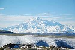 Mount Elbrus, the highest mountain in Europe, is located in Elbrussky District | |
| Location | |
| Country | Russia |
| Federal subject | Kabardino-Balkar Republic[1] |
| Administrative structure (as of April 2014) | |
| Administrative center | town of Tyrnyauz[1] |
| Inhabited localities:[1] | |
| Cities/towns | 1 |
| Rural localities | 10 |
| Municipal structure (as of April 2014) | |
| Municipally incorporated as | Elbrussky Municipal District[2] |
| Municipal divisions:[2] | |
| Urban settlements | 1 |
| Rural settlements | 6 |
| Statistics | |
| Area | 1,850.43 km2 (714.46 sq mi) |
| Population (2010 Census) | 36,260 inhabitants[3] |
| • Urban | 57.9% |
| • Rural | 42.1% |
| Density | 19.6/km2 (51/sq mi)[4] |
| Time zone | MSK (UTC+03:00)[5] |
| Official website | |
| Elbrussky District on WikiCommons | |
| 2010 Census | 36,260[3] |
|---|---|
| 2002 Census | 35,968[6] |
Elbrussky District (Russian: Эльбру́сский райо́н; Kabardian: Ӏуащхьэмахуэ къедзыгъуэ; Karachay-Balkar: Эльбрус район) is an administrative[1] and a municipal[2] district (raion), one of the ten in the Kabardino-Balkar Republic, Russia. It is located in the western and southwestern parts of the republic. The area of the district is 1,850.43 square kilometers (714.46 sq mi). Its administrative center is the town of Tyrnyauz.[1] As of the 2010 Census, the total population of the district was 36,260, with the population of Tyrnyauz accounting for 57.9% of that number.[3]
Administrative and municipal status
Within the framework of administrative divisions, Elbrussky District is one of the ten in the Kabardino-Balkar Republic and has administrative jurisdiction over one town (Tyrnyauz) and ten rural localities.[1] As a municipal division, the district is incorporated as Elbrussky Municipal District.[2] The town of Tyrnyauz is incorporated as an urban settlement and the ten rural localities are incorporated into six rural settlements within the municipal district.[2] The town of Tyrnyauz serves as the administrative center of both the administrative[1] and municipal[2] district.
References
Notes
- 1 2 3 4 5 6 7 Law #12-RZ
- 1 2 3 4 5 6 Law #13-RZ
- 1 2 3 Russian Federal State Statistics Service (2011). "Всероссийская перепись населения 2010 года. Том 1" [2010 All-Russian Population Census, vol. 1]. Всероссийская перепись населения 2010 года (2010 All-Russia Population Census) (in Russian). Federal State Statistics Service. Retrieved June 29, 2012.
- ↑ The value of density was calculated automatically by dividing the 2010 Census population by the area specified in the infobox. Please note that this value is only approximate as the area specified in the infobox does not necessarily correspond to the area of the entity proper or is reported for the same year as the population.
- ↑ Правительство Российской Федерации. Федеральный закон №107-ФЗ от 3 июня 2011 г. «Об исчислении времени», в ред. Федерального закона №271-ФЗ от 03 июля 2016 г. «О внесении изменений в Федеральный закон "Об исчислении времени"». Вступил в силу по истечении шестидесяти дней после дня официального опубликования (6 августа 2011 г.). Опубликован: "Российская газета", №120, 6 июня 2011 г. (Government of the Russian Federation. Federal Law #107-FZ of June 31, 2011 On Calculating Time, as amended by the Federal Law #271-FZ of July 03, 2016 On Amending Federal Law "On Calculating Time". Effective as of after sixty days following the day of the official publication.).
- ↑ Russian Federal State Statistics Service (May 21, 2004). "Численность населения России, субъектов Российской Федерации в составе федеральных округов, районов, городских поселений, сельских населённых пунктов – районных центров и сельских населённых пунктов с населением 3 тысячи и более человек" [Population of Russia, Its Federal Districts, Federal Subjects, Districts, Urban Localities, Rural Localities—Administrative Centers, and Rural Localities with Population of Over 3,000] (XLS). Всероссийская перепись населения 2002 года [All-Russia Population Census of 2002] (in Russian). Retrieved August 9, 2014.
Sources
- Парламент Кабардино-Балкарской Республики. Закон №12-РЗ от 27 февраля 2005 г. «Об административно-территориальном устройстве Кабардино-Балкарской Республики», в ред. Закона №20-РЗ от 23 апреля 2014 г. «О внесении изменений в отдельные республиканские Законы». Вступил в силу на следующий день после опубликования. Опубликован: "Кабардино-Балкарская правда", б/н, 1 марта 2005 г. (Parliament of the Kabardino-Balkar Republic. Law #12-RZ of February 27, 2005 On the Administrative-Territorial Structure of the Kabardino-Balkar Republic, as amended by the Law #20-RZ of April 23, 2014 On Amending Various Republican Laws. Effective as of the day following the publication date.).
- Парламент Кабардино-Балкарской Республики. Закон №13-РЗ от 27 февраля 2005 г. «Об статусе и границах муниципальных образований в Кабардино-Балкарской Республики», в ред. Закона №20-РЗ от 23 апреля 2014 г. «О внесении изменений в отдельные республиканские Законы». Вступил в силу на следующий день после официального опубликования. Опубликован: "Кабардино-Балкарская правда", б/н, 1 марта 2005 г. (Parliament of the Kabardino-Balkar Republic. Law #13-RZ of February 27, 2005 On the Status and the Borders of the Municipal Formations in the Kabardino-Balkar Republic, as amended by the Law #20-RZ of April 23, 2014 On Amending Various Republican Laws. Effective as of the day following the official publication date.).