Elbow Cays
| Elbow Cays Los Roques | |
|---|---|
| Cays | |
 View of the Elbow Cays. The semi-ruined lighthouse of North Elbow Cay can be seen in the background. | |
 Elbow Cays | |
| Coordinates: 23°57′N 80°27′W / 23.950°N 80.450°WCoordinates: 23°57′N 80°27′W / 23.950°N 80.450°W | |
| Country | The Bahamas |
| Region | Cay Sal Bank, Bahama Banks |
| District | Bimini |
| Population | |
| • Total | uninhabited |
| Languages | |
| • Official | English |
| Time zone | UTC−5 (EST) |
_p0216_BAHAMAS%2C_CAY_SAL_LIGHTHOUSE.jpg) Old drawing of the lighthouse. Although known as 'Cay Sal Lighthouse', it was not located on Cay Sal Island | |
 Cay Sal Bahamas | |
| Location |
Cay Sal Cay Sal Bank Bahamas |
|---|---|
| Coordinates | 23°57′12.6″N 80°26′42.0″W / 23.953500°N 80.445000°W |
| Year first constructed | 1839 |
| Deactivated | 1940s |
| Construction | stone tower |
| Tower shape | cylindrical tower with balcony and lantern |
| Markings / pattern | unpainted and ruined tower |
| Height | 18 metres (59 ft) |
| ARLHS number | BAH-018[1] |
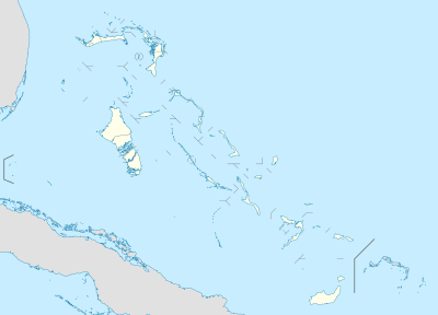
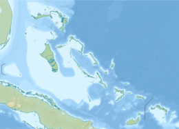
The Elbow Cays (Spanish: Los Roques)[2] are uninhabited cays in the Cay Sal Bank, Bahamas. They are part of a reef shelf located at the northwestern end of the bank about 80 km (50 mi) off the Cuban coast and 130 km (80 mi) southeast of Key West, Florida. These cays are an excellent scuba diving spot.[3]
The Elbow Cays are the westernmost group on the reef, running southwest to northeast along the Straits of Florida. The southernmost cays of this group consist of unnamed islets and rocks. Northeast of these are South Elbow Cay (the westernmost named cay of Cay Sal Bank) and North Elbow Cay, the latter sometimes known just as Elbow Cay (Spanish: Cayo Codo).[4]
North Elbow Cay, which is the largest and highest of the cays, is marked by a disused conical stone lighthouse, which is 17.7 metres (58 ft) high. The site is open for visitors, but the ruined tower is accessible only by boat and reaching it is extremely hazardous.[5]
Geography
The compact cluster of islets, rocks and reefs formed by Elbow Cays, Crenula Cay, Double Headed Shot Cays, Water Cays and Marion Rock, among other unnamed features, was named by the Spanish as Los Roques. These northwestern cays gave their name to the whole bank, which is known as Placer de los Roques, in the Spanish language.[6]
Adjacent islands and rocks
- Crenula Cay 23°58′40″N 80°21′52″W / 23.97778°N 80.36444°W
- Double Headed Shot Cays, 23°59′50″N 80°19′15″W / 23.99722°N 80.32083°W, a group of elongated cays that extend northeastward from the Elbow Cays, incorporating the Water Cays and all islets and reefs up to the Deadman Cays in the east.[7] They are in a position on the northwest side of Cay Sal Bank where the Florida Current, in its course east and north through the Straits of Florida, usually sets close offshore at full strength.
- Water Cays (Spanish: Cayo del Agua) (West Water Cay and East Water Cay), 23°59′26″N 80°20′26″W / 23.99056°N 80.34056°W. Located towards the northeastern end these cays were mentioned by Alexander Von Humboldt:
Cayos del Agua (lat. 23° 58', long. 82° 56'), in the Placer de los Roques or the Cayo de Sal. I place the Cayo del Agua a little more to the west than Captain Steetz did on the interesting maps that accompany his Instruction nautique sur les Passages à l'île de Cuba, 1825, p. 55.[8]
- Marion Rock, 24°01′30″N 80°20′30″W / 24.02500°N 80.34167°W, a submerged rock Located off the northern coast of the 'Los Roques' reef.
History
Spanish navigators visited the island, plotting it for the first time on a map in 1511 as Los Roques. The island and its atoll were subsequently claimed for the Spanish crown by Juan Ponce de León.[3] The island was under the Spanish rule for about two centuries until 1718 when the Bahamas became a Crown colony of the British Empire.
A tall stone lighthouse was built by the British on the island of North Elbow Cay in 1839 along with some small buildings.[3] It marked the southern entrance to the Florida Straits from the Gulf of Mexico and was active until the 1940s. The abandoned lighthouse was briefly reactivated during the 1970s, when Bahamas police set up a post on nearby Cay Sal Island to watch for drug smugglers.[5] Many Cubans attempting to cross the Straits of Florida on makeshift boats and rafts reached this cay and wrote their names in the ruins of the lighthouse.[3]
Cartography
In ancient maps and nautical charts the size of these cays was often exaggerated.
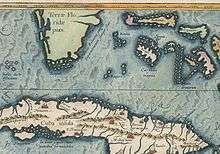 Los Roques in Atlas Ortelius ca 1580 |
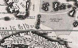
_-_AHG.jpg) Los Roques in a 1594 Spanish map. |
 Los Roques in a 1696 Danckerts map. |
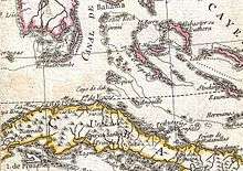 Los Roques in a 1779 map. |
See also
References
- ↑ Cay Sal The Lighthouse Directory. University of North Carolina at Chapel Hill. Retrieved 25 August 2016
- ↑ Derrotero de las islas Antillas, de las costas Tierra-Firme, y las del Seno Mejicano, Dirección de Hidrografía, España, Madrid, Imprenta Nacional, 1837. p. 266
- 1 2 3 4 Cay Sal Bank Lighthouse: A Stately Ruin
- ↑ NGA Navigational Chart #27087, Cay Sal Bank. 3rd Edition, corrected through Mar-01.
- 1 2 Lighthouses of the Bahamas
- ↑ Derrotero de las islas Antillas, de las costas Tierra-Firme, y las del Seno Mejicano, Dirección de Hidrografía, España, Madrid, Imprenta Nacional, 1837. p. 265
- ↑ NOAA Navigational Chart #11013, Atlantic Coast: Straits of Florida and Approaches. 48th Edition, corrected though Feb-12. Available as a NOAA Raster Navigational Chart at the NOAA Office of Coast Survey RNC Downloads website.
- ↑ Alexander Von Humboldt, Political Essay on the Island of Cuba: A Critical Edition, ed. and transl. by Vera M. Kutzinski and Ottmar Ette, University of Chicago Press, p. 61