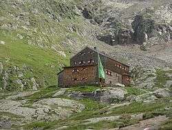
Elberfelder Hut
| Elberfelder Hut | |
|---|---|
 | |
| Coordinates | 46°58′40″N 12°45′37″E / 46.97778°N 12.76028°ECoordinates: 46°58′40″N 12°45′37″E / 46.97778°N 12.76028°E |
| Administrative district | Carinthia, Austria |
| Location | Upper Gößnitz valley |
| Nearest settlement | Heiligenblut |
| Elevation | 2,346 m (7,697 ft) |
| Construction | |
| Built in | 1928 |
| Administration | |
| Hut type | DAV hut Category I |
| Owner | Elberfeld Branch of the German Alpine Club |
| Website |
www |
| Facilities | |
| Beds/Bunks | 12 |
| Mattresses | 44 |
| Emergency beds | 5 |
| Winter room | 5 |
| Opening times | mid-June to mid-September |
| Footnotes | |
| Hut reference | DAV |
The Elberfelder Hut (German: Elberfelder Hütte) is a mountain hut belonging to the German Alpine Club in the Schober Group within the Austrian Alps.
The mountain hut stands at 2,346 m in the upper Gößnitz valley and is managed from mid-June to mid-September. The Wuppertal branch of the German Alpine Club is responsible for it. The Siegburg and Recklinghausen branches also participate in managing the hut.
History
The Elberfelder Hut was built in 1928. In the years 1982 and 1983, following an avalanche, the hut was renovated and extended. In 2005 repair work was carried out on the façade and roof.[1] The hut has its own hydropower station to provide power and is exclusively supplied by helicopter.
The house is named after the Wuppertal quarter of Elberfeld.
Ascents
- From Heiligenblut on the Elberfelder Weg through the Gößnitztal in 4 to 5 hours
- From Heiligenblut via the Langtalseen in 6 hours
- Via the Lienzer Hut and Gößnitz col (Gößnitzscharte): 4 hours
All timings refer to the actual journey time without stops and delays.
Tours
Summit tours
- Roter Knopf, 3,281 m above sea level (AA) to the second-highest peak in the Schober Group in 3½ hours.
- Böses Weibl, 3,119 m above sea level (AA) along the Vienna Ridgeway (Wiener Höhenweg) in 3 hours.
- Kreuzkopf, 3,103 m above sea level (AA), 2½ hours.
- Glödis, 3,206 m above sea level (AA), 5½ hours.
Crossings
The Elberfelder Hut is on the Vienna Ridgeway, which runs from the Iselsberg to the Glocknerhaus. Its neighbouring huts are reached as follows:
- To the Adolf-Noßberger Hut there is a crossing using the Vienna Ridgeway via the Horn Col (Hornscharte) (2,958 m above sea level (AA)), which takes 5 hours of journey time.
- The shorter crossing to the Noßberger Hut via the Klammer Col (Klammerscharte) is only advisable in good snow conditions. From mid-July it is usually dangerous and not recommended due to the high risk of rockfalls and lack of snow.
- Also on the Vienna Ridgeway is the Glorer Hut in the Glockner Group which may be reached in 5–6 hours via the Kesselkees Saddle and the Peischlachtörl.
- Via the Gößnitz Col (Gößnitzscharte, 2,737 m above sea level (AA)) ) south of the hut to the Lienzer Hut in 3–4 hours.
- Via the Leibniztörl (2,591 m above sea level (AA)) in 7 hours to the Hochschober Hut.
Accident
On 8 September 2016, shortly after take-off, a helicopter on the return leg of a supply flight to the Elberfelder Hut, crashed into the mountainside killing its pilot, Hannes Arch. The hut manager, who had spontaneously decided to accompany Arch, was injured but was able to be rescued.[2]
Literature
- Alpenvereinskarte 41 Schobergruppe. Deutscher Alpenverein, Munich, 2005.
External links
References
- ↑
- ↑ Hannes Arch: Suche nach Absturzursache. In: ORF, 9 September 2016.