San Gabriel Valley Airport
| San Gabriel Valley Airport | |||||||||||
|---|---|---|---|---|---|---|---|---|---|---|---|
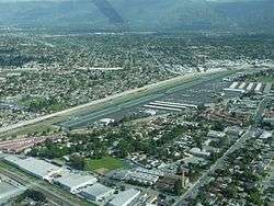 Aerial view of the airport, facing NorthWest | |||||||||||
| Summary | |||||||||||
| Airport type | County of Los Angeles | ||||||||||
| Operator | American Airports Corp. | ||||||||||
| Serves | El Monte, California | ||||||||||
| Location | El Monte, California | ||||||||||
| Elevation AMSL | 296 ft / 90 m | ||||||||||
| Coordinates | 34°05′10″N 118°02′05″W / 34.08611°N 118.03472°WCoordinates: 34°05′10″N 118°02′05″W / 34.08611°N 118.03472°W | ||||||||||
| Runways | |||||||||||
| |||||||||||
San Gabriel Valley Airport (formerly El Monte Airport) (IATA: EMT, ICAO: KEMT, FAA LID: EMT) is a public airport one mile (1.6 km) north of El Monte, in Los Angeles County, California. The airport covers 103 acres (42 ha) and has one runway. In November 2014, the airport's name was officially changed from El Monte Airport to San Gabriel Valley Airport.[1]
References
- ↑ Day, Brian (November 16, 2014). "Airfield in El Monte christened as San Gabriel Valley Airport during air fair". Pasadena Star News. Retrieved November 16, 2014.
External links
Places adjacent to San Gabriel Valley Airport | ||||||||||
|---|---|---|---|---|---|---|---|---|---|---|
| ||||||||||
- FAA Airport Diagram (PDF), effective October 11, 2018
- Resources for this airport:
- FAA airport information for EMT
- AirNav airport information for KEMT
- ASN accident history for EMT
- FlightAware airport information and live flight tracker
- NOAA/NWS latest weather observations
- SkyVector aeronautical chart, Terminal Procedures

This article is issued from
Wikipedia.
The text is licensed under Creative Commons - Attribution - Sharealike.
Additional terms may apply for the media files.