El Limón, Herrera
| El Limón | |
|---|---|
| Corregimiento | |
 El Limón | |
| Coordinates: 8°03′50″N 80°45′00″W / 8.06389°N 80.75000°WCoordinates: 8°03′50″N 80°45′00″W / 8.06389°N 80.75000°W | |
| Country |
|
| Province | Herrera |
| District | Santa María |
| Established | July 29, 1998[1] |
| Area[1] | |
| • Land | 23.8 km2 (9.2 sq mi) |
| Population (2010)[1] | |
| • Total | 1,221 |
| • Density | 51.3/km2 (133/sq mi) |
| Population density calculated based on land area. | |
| Time zone | UTC−5 (EST) |
El Limón is a corregimiento in Santa María District, Herrera Province, Panama with a population of 1,221 as of 2010.[1] It was created by Law 58 of July 29, 1998, owing to the Declaration of Unconstitutionality of Law 1 of 1982.[1] Its population as of 2000 was 1,146.[1]
References
- 1 2 3 4 5 6 "Cuadro 11 (Superficie, población y densidad de población en la República...)" [Table 11 (Area, population, and population density in the Republic...)] {{webarchive |url=https://web.archive.org/web/20160304030354/http://www.contraloria.gob.pa/inec/archivos/P3601Cuadro11.xls |date=March 4, 2016 }} (.xls). In "Resultados Finales Básicos" [Basic Final Results] (in Spanish). National Institute of Statistics and Census of Panama. Archived from the original on July 10, 2015. Retrieved May 26, 2015.
Capital: Chitré | ||
| Chitré District | 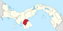 | |
| Las Minas District | ||
| Los Pozos District | ||
| Ocú District | ||
| Parita District | ||
| Pesé District | ||
| Santa María | ||
This article is issued from
Wikipedia.
The text is licensed under Creative Commons - Attribution - Sharealike.
Additional terms may apply for the media files.