El Chico National Park

El Chico National Park is a protected area in the State of Hidalgo, Mexico. It is one of the oldest protected areas in Mexico, as its foundation dates to 1898 when the then president of the republic, General Porfirio Díaz, by decree, created "Monte Vedado del Mineral del Chico".[1] Since this date, the ancient conifer forests have been protected from the deforestation suffered in other parts of the country. Another decree followed in 1915 and still another by Presidential Agreement on 13 September 1922, which declared Monte Vedado to be cataloged as a forest reservation.
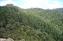
The park has an extensive and varied ecosystem typical of the region. It contains large forests of conifers, several species of animals of which many are endemic to the region, and numerous rocky outcropings, small valleys, lagoons and rivers. The park attracts visitors with climbing, hiking, and camping.
Decree
El Chico National Park was created by means of an official decree issued on 6 July 1982. It has a surface area of 2,739 hectares (6,770 acres), and is located in the Pachuca Mountains, Hidalgo.[2]
Orography
The highland zone is in the Pachuca Mountain range. It is of volcanic origin and its limits split it north of the Valley of Mexico. This range forms part of the mountainous system knows as the Trans-Mexican Volcanic Belt, which then joins the Sierra Madre Oriental. Elevations range between 2,300–3,090 metres (7,550–10,140 ft) above sea level. The majority of these elevations feature rocky crags of volcanic origin that they are eroded by climate. The best known of these are Las Ventanas at 3,090 metres (10,140 ft), as well as Las Monjas, La Peña del Cuervo, La Peña del Sumate, La Muela, Los Enamorados, and La Fortaleza.
Hydrography

In this highland zone, there are several springs which form rivers and tributaries, crossing the greater part of the park. There are waterfalls associated with Río el Milagro. The hydrological basin is that of the Pánuco River. Sportive fishing occurs at El Cedral.
Flora and fauna
This forest presents one of the best ecosystems preserved in the zone that corresponds to the splits between the North and the Valley of Mexico. Vegetation is diverse, housing some endemic species and others that are not very abundant or predominate in the country, in particular the Cupressus which is not very common in the Mexican forests.[3]
The species of trees are represented by some of the following: Pinus teocote and Pinus rudis; Abies, particularly Abies religiosa; Quercus, particularly Quercus laurina, Quercus affinis, Quercus rugosa, Quercus glandulosa, and Quercus mexicana.. Of Cupressus, Cupressus lusitanica and Cupressus benthamii are featured. Also observed is species of Juniperus monticola that forms groups of thickets.
The park forms part of the designated Trans-Mexican Volcanic Belt. A total of 17 species have been categorized for special protection under the agreement NOM-59-SEMARNAT-2001).
Recreation
A visitor center and park office provide tourist information, a cafeteria, audiovisual area, and exhibition area. There is also a tower for detection and surveillance against forest fires. There is also the Alpine Hostel “Miguel Hidalgo”, a trailer park , the Oriel “Crag of the Raven”, and two low impact, ecotourist camp sites.
Notas
- ↑ Decreto que establece como Bosque Nacional el terreno llamado Monte Vedado del Minreal del Chico, Distrito de Pachuca, del Estado de Hidalgo (in Spanish)
- ↑ Decree to create the park (in Spanish)
- ↑ En la sección de aspectos biológicos del Parque Nacional El Chico, en la web de planeta.com. Archived 2015-09-24 at the Wayback Machine. (in Spanish)
External links
Coordinates: 20°12′26″N 98°43′52″W / 20.207222°N 98.731111°W