Eirinoupoli
| Eirinoupoli Ειρηνούπολη | |
|---|---|
 Eirinoupoli Location within the regional unit 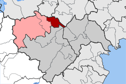 | |
| Coordinates: 40°41′N 22°12′E / 40.683°N 22.200°ECoordinates: 40°41′N 22°12′E / 40.683°N 22.200°E | |
| Country | Greece |
| Administrative region | Central Macedonia |
| Regional unit | Imathia |
| Municipality | Naousa |
| • Municipal unit | 50.0 km2 (19.3 sq mi) |
| Elevation | 25 m (82 ft) |
| Population (2011)[1] | |
| • Municipal unit | 3,808 |
| • Municipal unit density | 76/km2 (200/sq mi) |
| Time zone | UTC+2 (EET) |
| • Summer (DST) | UTC+3 (EEST) |
| Vehicle registration | ΗΜ |
Eirinoupoli (Greek: Ειρηνούπολη) is a former municipality in Imathia, Central Macedonia, Greece. Since the 2011 local government reform it is part of the municipality Naousa, of which it is a municipal unit.[2] The municipal unit has an area of 49.962 km2.[3] Population 3,808 (2011). It has 5 villages (Angelochori, Ano Zervochori, Kato Zervochori, Polyplatanos and Archangelos). Its elevation is 25 meters (82 feet).[4]
References
- ↑ "Απογραφή Πληθυσμού - Κατοικιών 2011. ΜΟΝΙΜΟΣ Πληθυσμός" (in Greek). Hellenic Statistical Authority.
- ↑ Kallikratis law Greece Ministry of Interior (in Greek)
- ↑ "Population & housing census 2001 (incl. area and average elevation)" (PDF) (in Greek). National Statistical Service of Greece. Archived from the original (PDF) on 2015-09-21.
- ↑ Greece - Places beginning with Eirinoupoli - Eirinoupoli to Elafos
This article is issued from
Wikipedia.
The text is licensed under Creative Commons - Attribution - Sharealike.
Additional terms may apply for the media files.