Eggjarnar
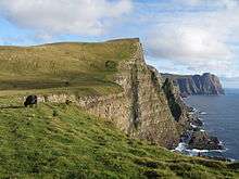
Eggjarnar (also called Skúvanes, 200 metres above sea level) is a place south of the village of Vágur on Suðuroy island in the Faroe Islands, which is known for its scenic viewpoint to the sea-cliffs of the southern part of Suðuroy all the way to Beinisvørð in the south and to Vágseiði and Gjógvaráfjall in the north.
The Loran-A Station
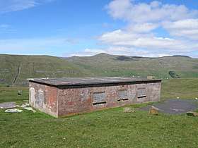
During World War II the Americans built a LORAN A station south of Vágur on Eggjarnar and raised four high masts, LORAN referring to long-range navigation. The first signal went on air on 15 October 1943. The British military which had occupied the Faroe Islands shortly after Germany occupied Denmark, used the Loran-A station to guide British aircraft and ships across the Atlantic. The Loran-A station continued to work after the war ended, it was taken over by the Danes in 1946; and it was in function until December 1977.[1] The ruins of the Loran-A station and of some of the other buildings from the World War II period can still be seen on Eggjarnar.
 View from Eggjarnar towards north to Vágseiði and Gjógvaráfjall
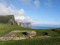 World War II Remains of a British Concrete Gun Pit on Eggjarnar.
References
External links
- Visitsuduroy.fo, The Tourist Information Center of Suðuroy.
- Vagur.fo, The Municipality of Vágur.
Coordinates: 61°27′25″N 6°49′48″W / 61.457°N 6.830°W