Edenborn, Pennsylvania
| Edenborn, Pennsylvania | ||
|---|---|---|
| Census-designated place | ||
| ||
 Edenborn  Edenborn | ||
| Coordinates: 39°52′55″N 79°53′15″W / 39.88194°N 79.88750°WCoordinates: 39°52′55″N 79°53′15″W / 39.88194°N 79.88750°W | ||
| Country | United States | |
| State | Pennsylvania | |
| County | Fayette | |
| Township | German | |
| Area | ||
| • Total | 0.38 sq mi (0.98 km2) | |
| • Land | 0.38 sq mi (0.98 km2) | |
| • Water | 0.0 sq mi (0.0 km2) | |
| Elevation | 1,040 ft (320 m) | |
| Population (2010) | ||
| • Total | 294 | |
| • Density | 775/sq mi (299.2/km2) | |
| Time zone | UTC-5 (Eastern (EST)) | |
| • Summer (DST) | UTC-4 (EDT) | |
| FIPS code | 42-22344 | |
| GNIS feature ID | 2634216 | |
Edenborn is an unincorporated community and census-designated place in German Township, Fayette County, Pennsylvania, United States. It is located along Pennsylvania Route 166, just north of Pennsylvania Route 21. Uniontown is 10 miles (16 km) to the east, Brownsville is 11 miles (18 km) to the north, and Waynesburg is 18 miles (29 km) to the west. As of the 2010 census the population was 294.[1]
References
- ↑ "Geographic Identifiers: 2010 Census Summary File 1 (G001), Edenborn CDP, Pennsylvania". American FactFinder. U.S. Census Bureau. Retrieved July 25, 2016.
External links
Municipalities and communities of Fayette County, Pennsylvania, United States | ||
|---|---|---|
| Cities | 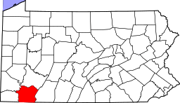 | |
| Boroughs | ||
| Townships | ||
| CDPs | ||
| Unincorporated communities |
| |
| Footnotes | ‡This populated place also has portions in an adjacent county or counties | |
This article is issued from
Wikipedia.
The text is licensed under Creative Commons - Attribution - Sharealike.
Additional terms may apply for the media files.