Echimamish River
| Echimamish River | |
| Country | Canada |
|---|---|
| Province | Manitoba |
| Region | Northern Region |
| Landmark | Painted Stone Portage |
| Source | Hayes River |
| - coordinates | 54°22′54″N 96°32′05″W / 54.38167°N 96.53472°W |
| Mouth | Nelson River |
| - coordinates | 54°19′39″N 97°26′29″W / 54.32750°N 97.44139°WCoordinates: 54°19′39″N 97°26′29″W / 54.32750°N 97.44139°W |
| Length | 60 km (37 mi) |
 Location of Echimamish River in Manitoba. | |
The Echimamish River is a river bifurcation in northern Manitoba Canada. It has the curious property of flowing between two river systems, in this case, the Hayes River and the Nelson River. Located 70 kilometres (43 mi) northeast of the northern tip of Lake Winnipeg, it is about 60 kilometres (37 mi) long and runs almost exactly east-west. It flows through totally flat swampy country and has a barely detectable current. Flowing through peat bogs, the water acquires a dark color, hence the old name of Blackwater Creek. Since it is shallow canoe navigation is helped by beaver ponds. Morse (references below) claims that it flows in two directions from a central beaver pond. On the Echimamish is the Painted Stone Portage. This is not the divide between the two river basins, but a short (20 paces) carry around a shallow and rocky section. The only other obstacles are beaver dams.[1][2][3]
Historic route
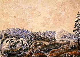
It was part of the voyageur route from Hudson Bay to Lake Winnipeg. Since most of the Nelson River is difficult, canoe and York boat brigades would take the easier Hayes and use the Echimamish to reach the upper Nelson and Lake Winnipeg. The first European to use the River may have been Joseph Smith in 1757. For background see Canadian canoe routes (early).
In 2006 the historic 600-kilometre (370 mi) route from York Factory to Norway House which includes the Hayes River, the Echimamish and a portion of the Nelson River was designated part of the Canadian Heritage Rivers System.[4]
See also
- List of rivers of Manitoba
- Casiquiare canal (river bifurcation in South America)
- List of unusual drainage systems
References
- ↑ "Google Maps Distance Calculator". Retrieved 2015-01-07.
- ↑ "Natural Resources Canada-Canadian Geographical Names (Echimamish River)". Retrieved 2015-01-07.
- ↑ "Atlas of Canada Toporama". Retrieved 2015-01-07.
- ↑ "Hayes River - Facts". Canadian Heritage Rivers System. Retrieved 2015-01-12.
Notes
- Eric C. Morse, 'Fur Trade Canoe Routes of Canada/Then and Now',1984, page 40