East Peak (New Haven County, Connecticut)
- Should not be confused with East Rock, another traprock summit in Connecticut
| East Peak | |
|---|---|
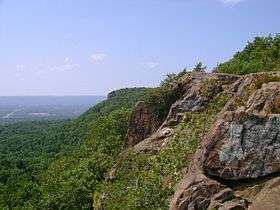 View from East Peak. | |
| Highest point | |
| Elevation | 976 ft (297 m) |
| Coordinates | 41°33′27″N 72°50′14″W / 41.55750°N 72.83722°WCoordinates: 41°33′27″N 72°50′14″W / 41.55750°N 72.83722°W |
| Geography | |
| Location | Meriden, Connecticut |
| Parent range | Hanging Hills / Metacomet Ridge |
| Geology | |
| Age of rock | 200 million yrs. |
| Mountain type | fault-block; igneous |
| Climbing | |
| Easiest route | Auto road |
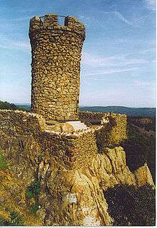
East Peak, 976 feet (297 m), is a prominent basalt traprock mountain in the Hanging Hills of Meriden, Connecticut. Rugged and scenic, the peak rises steeply above the city of Meriden 600 feet (183 m) below and is characterized by its vertical cliffs and sweeping views of southern Connecticut and Long Island Sound. A small stone observation tower known as Castle Craig stands on the summit.
East Peak is located within the 1,800-acre (7.3 km2) Hubbard Park. The 51-mile (82 km) Metacomet Trail crosses East Peak, and a seasonal auto road climbs to a small parking lot at Castle Craig. Activities enjoyed on the peak include Hiking, bicycling, and in the winter, cross-country skiing on the road. Although East Peak appears on a number of rock climbing websites, the brochure to Hubbard Park indicates that the areas is closed to rock climbing.[1]
See also
References
- ↑ "Hubbard Park" (PDF). South Central Regional Council of Governments. Retrieved March 7, 2012.
External links
- "Hubbard Park Hiking Trails" (PDF). Meriden Land Trust. Retrieved March 5, 2012.
- Connecticut Walk Book 17th ed. Connecticut Forest and Park Association.
- The City of Meriden