East Neuk
The East Neuk (![]()
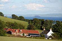
"Neuk" is the Scots word for nook or corner, and the East Neuk is generally accepted to comprise the fishing villages of the most northerly part of the Firth of Forth and the land and villages slightly inland therefrom. In effect, this means that part to the south of a line drawn parallel to the coast from just north of Earlsferry to just north of Crail. As such it would include Elie and Earlsferry, Colinsburgh, St Monans, Pittenweem, Arncroach, Carnbee, Anstruther, Cellardyke, Kilrenny, Crail and Kingsbarns.
The area houses a Cold War era bunker near Crail. Built in the late 1950s to be a regional seat of government in the event of a nuclear war, it is now a tourist attraction. [1]
References
- ↑ "Scotland's Secret Bunker". www.secretbunker.co.uk. Retrieved 2017-10-03.
External links
- Collins Encyclopaedia of Scotland, John Keay
- The East Neuk of Fife: Its History and Antiquities, Geology, Botany, and Natural History in General, Rev. Walter Wood, A.M.
- Rick Steves' Great Britain 2008, Rick Steves
- Biographical Dictionary of Eminent Men of Fife, M. F. Conolly 1866
- Fife Place-name Data