East Fork Eagle River
| East Fork Eagle River[1] | |
|---|---|
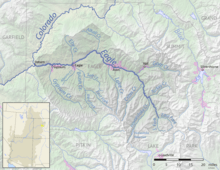 Eagle River drainage basin, with East Fork at bottom right | |
| Physical characteristics | |
| Main source | 39°21′55″N 106°15′17″W / 39.36528°N 106.25472°W |
| River mouth |
Confluence with South Fork 9,295 ft (2,833 m) 39°25′18″N 106°18′48″W / 39.42167°N 106.31333°WCoordinates: 39°25′18″N 106°18′48″W / 39.42167°N 106.31333°W |
| Basin features | |
| Progression | Eagle—Colorado |
East Fork Eagle River is an 8.6-mile-long (13.8 km)[2] tributary of the Eagle River in Eagle County, Colorado. The river flows from a source on Chicago Ridge in the White River National Forest to a confluence with the South Fork Eagle River that forms the Eagle River.
See also
References
- ↑ "East Fork Eagle River". Geographic Names Information System. United States Geological Survey. Retrieved 2011-02-08.
- ↑ U.S. Geological Survey. National Hydrography Dataset high-resolution flowline data. The National Map Archived 2012-04-05 at WebCite, accessed March 18, 2011
This article is issued from
Wikipedia.
The text is licensed under Creative Commons - Attribution - Sharealike.
Additional terms may apply for the media files.