East Calais, Vermont
| East Calais, Vermont | |
|---|---|
| Village | |
 East Calais | |
| Coordinates: 44°21′59″N 72°25′47″W / 44.36639°N 72.42972°WCoordinates: 44°21′59″N 72°25′47″W / 44.36639°N 72.42972°W | |
| Country | United States |
| State | Vermont |
| County | Washington |
| Elevation | 843 ft (257 m) |
| Time zone | UTC-5 (Eastern (EST)) |
| • Summer (DST) | UTC-4 (EDT) |
| ZIP code | 05650 |
| Area code(s) | 802 |
| GNIS feature ID | 1457265[1] |
East Calais is an unincorporated village in the town of Calais, Washington County, Vermont, United States. The community is located along Vermont Route 14 10.3 miles (16.6 km) northeast of Montpelier. East Calais has a post office with ZIP code 05650, which opened on April 12, 1830.[2][3]
References
- ↑ "East Calais". Geographic Names Information System. United States Geological Survey.
- ↑ United States Postal Service. "USPS - Look Up a ZIP Code". Retrieved May 11, 2017.
- ↑ "Postmaster Finder - Post Offices by ZIP Code". United States Postal Service. Retrieved May 11, 2017.
Municipalities and communities of Washington County, Vermont, United States | ||
|---|---|---|
| Cities | 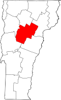 | |
| Towns | ||
| Villages | ||
| CDPs | ||
| Other communities | ||
This article is issued from
Wikipedia.
The text is licensed under Creative Commons - Attribution - Sharealike.
Additional terms may apply for the media files.