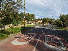
Easington, North Yorkshire
| Easington | |
|---|---|
 Easington village | |
 Easington Easington shown within North Yorkshire | |
| OS grid reference | NZ744181 |
| • London | 210 mi (340 km) S |
| Unitary authority | |
| Ceremonial county | |
| Region | |
| Country | England |
| Sovereign state | United Kingdom |
| Post town | SALTBURN-BY-THE-SEA |
| Postcode district | TS13 |
| Dialling code | 01287 |
| Police | Cleveland |
| Fire | Cleveland |
| Ambulance | North East |
| EU Parliament | North East England |
| UK Parliament | |
Easington is a village in the unitary authority of Redcar and Cleveland and the ceremonial county of North Yorkshire, England.
Historically part of the North Riding of Yorkshire, the village is situated on the A174 road 1 mile (1.6 km) east from Loftus, and inside the North York Moors National Park.[1]
Easington's church, dedicated to All Saints', is Grade II listed. The church was built in 1888–89 by C. Hodgson Fowler in Decorated style, largely with bequests from the Palmer family of Grinkle Park, and incorporated fragments and remains of the previous church.[2][3][4] The side chapel and several of the furnishings are by the firm of 'Mousey' Thompson of Kilburn.
The village public house, the Tiger Inn, was previously a building of the same name at the opposite end of the village.
The village had a railway station on the Whitby, Redcar and Middlesbrough Union Railway. The station was opened in 1883 as Easington, the name changing in 1904 to Grinkle after the local house and seat of the Baronets Palmer, Grinkle Park. The renaming was to avoid confusion with the station at the larger Easington, County Durham, also on the North Eastern Railway's network. The station closed on the eve of the Second World War and never re-opened although the line still exists as a freight only railway to Boulby Mine.[5]
Palmer Baronetcy
The Palmer Baronetcy, of Grinkle Park in the County of York and of Newcastle upon Tyne, was created in the Baronetage of the United Kingdom on 31 July 1886 for Charles Palmer, a coal and shipping magnate and Liberal politician.[4]
References
- ↑ "OL27" (Map). North York Moors - Eastern Area. 1:25,000. Explorer. Ordnance Survey. 2016. ISBN 9780319242667.
- ↑ Historic England. "Church of All Saints, Loftus (Grade II) (1139699)". National Heritage List for England. Retrieved 25 October 2014.
- ↑ "All Saints, Easington", The Church of England, (Achurchnearyou.com). Retrieved 25 October 2014
- 1 2 "'Parishes: Easington', A History of the County of York North Riding: Volume 2 (1923), pp. 340–343". British History Online. Retrieved 18 March 2012.
- ↑ "Disused Stations: Grinkle Station". www.disused-stations.org.uk. Retrieved 25 September 2017.
External links
