Earl, Oklahoma
| Earl | |
|---|---|
| Unincorporated community | |
 Earl Location within the state of Oklahoma  Earl Earl (the US) | |
| Coordinates: 34°12′06″N 96°53′52″W / 34.20167°N 96.89778°WCoordinates: 34°12′06″N 96°53′52″W / 34.20167°N 96.89778°W | |
| Country | United States |
| State | Oklahoma |
| County | Johnston |
| Time zone | UTC-6 (Central (CST)) |
| • Summer (DST) | UTC-5 (CDT) |
| GNIS feature ID | 1092342 |
Earl is an unincorporated community in Johnston County, Oklahoma.[1] A post office operated in Earl from 1893 to 1908.[2]
References
- ↑ U.S. Geological Survey Geographic Names Information System: Earl, Oklahoma
- ↑ Shirk, George H. Oklahoma Place Names. Norman, Oklahoma: University of Oklahoma Press, 1965, p.69.
Municipalities and communities of Johnston County, Oklahoma, United States | ||
|---|---|---|
| City | 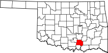 | |
| Towns | ||
| CDP | ||
| Unincorporated communities | ||
| Footnotes | ‡This populated place also has portions in an adjacent county or counties | |
This article is issued from
Wikipedia.
The text is licensed under Creative Commons - Attribution - Sharealike.
Additional terms may apply for the media files.