Eagle Cap
| Eagle Cap | |
|---|---|
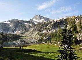 Eagle Cap above Mirror Lake | |
| Highest point | |
| Elevation | 9,577 ft (2,919 m) NAVD 88[1] |
| Prominence | 1,212 ft (369 m) [1] |
| Listing | Oregon county high points |
| Coordinates | 45°09′49″N 117°18′06″W / 45.1634868°N 117.3015695°WCoordinates: 45°09′49″N 117°18′06″W / 45.1634868°N 117.3015695°W [2] |
| Geography | |
 Eagle Cap Location in Oregon | |
| Location | Wallowa-Whitman National Forest, Union County, Oregon, U.S. |
| Parent range | Wallowa Mountains |
| Topo map | USGS Eagle Cap |
| Climbing | |
| Easiest route | Scramble |
Eagle Cap (9,577 feet (2,919 m) is a mountain peak located in the Wallowa Mountains, Wallowa–Whitman National Forest, in the U.S. state of Oregon.[2] The peak is in the Eagle Cap Wilderness and the Benson Glacier is along the east flank of the summit ridge. Its summit is the highest point in Union County[1]
References
- 1 2 3 "Eagle Cap, Oregon". Peakbagger.com. Retrieved 2012-07-28.
- 1 2 "Eagle Cap". Geographic Names Information System. United States Geological Survey. Retrieved 2012-07-28.
External links
- "Eagle Cap". SummitPost.org.
This article is issued from
Wikipedia.
The text is licensed under Creative Commons - Attribution - Sharealike.
Additional terms may apply for the media files.