Dypvåg (village)
| Dypvåg | |
|---|---|
| Village | |
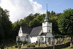 View of the village church | |
 Dypvåg Location of the village  Dypvåg Dypvåg (Norway) | |
| Coordinates: 58°37′35″N 9°03′08″E / 58.6263°N 09.0523°ECoordinates: 58°37′35″N 9°03′08″E / 58.6263°N 09.0523°E | |
| Country | Norway |
| Region | Southern Norway |
| County | Aust-Agder |
| District | Østre Agder |
| Municipality | Tvedestrand |
| Elevation[1] | 35 m (115 ft) |
| Time zone | UTC+01:00 (CET) |
| • Summer (DST) | UTC+02:00 (CEST) |
| Post Code | 4900 Tvedestrand |
Dypvåg is a village in Tvedestrand municipality in Aust-Agder county, Norway. The village is located along the Skagerrak coast and the Norwegian County Road 411, about 10 kilometres (6.2 mi) east of the town of Tvedestrand and the village of Kråkvåg lies immediately west of Dypvåg. The village was the administrative centre of the old municipality of Dypvåg which existed from 1838 until its dissolution in 1960. The historic Dypvåg Church is located in the village.[2]
Name
The village is named after the old Dybvaag farm (Old Norse: Djúpvágr or Djúpivágr), since the first Dypvåg Church was built there. The first element comes from dype which means "deep" and the last element is våg which means "water" or "harbor". The spelling was changed from Dybvaag to Dypvåg around the early 20th century.[3]
Notable residents
- Jens Marcussen (1926-2007), a politician
- Kristian Vilhelm Koren Schjelderup, Jr. (1894-1980), a theologian
- Peter Olrog Schjøtt (1833-1926), a philologist
References
- ↑ "Dypvåg, Tvedestrand (Aust-Agder)". yr.no. Retrieved 2018-01-01.
- ↑ Thorsnæs, Geir, ed. (2015-07-24). "Dypvåg – tettbebyggelse i Tvedestrand". Store norske leksikon (in Norwegian). Kunnskapsforlaget. Retrieved 2017-12-30.
- ↑ Rygh, Oluf (1905). Norske gaardnavne: Nedenes amt (in Norwegian) (8 ed.). Kristiania, Norge: W. C. Fabritius & sønners bogtrikkeri. p. 36.