Durwood, Oklahoma
| Durwood | |
|---|---|
| Unincorporated community | |
 Durwood Location within the state of Oklahoma  Durwood Durwood (the US) | |
| Coordinates: 34°10′36″N 96°57′53″W / 34.17667°N 96.96472°WCoordinates: 34°10′36″N 96°57′53″W / 34.17667°N 96.96472°W | |
| Country | United States |
| State | Oklahoma |
| County | Carter |
| Time zone | UTC-6 (Central (CST)) |
| • Summer (DST) | UTC-5 (CDT) |
| GNIS feature ID | 1100372 |
Durwood is an unincorporated community located in Carter County, Oklahoma.[1] The elevation is 843 feet.[2]
References
- ↑ U.S. Geological Survey Geographic Names Information System: Durwood, Oklahoma
- ↑ "Durwood, Oklahoma". Retrieved 18 August 2014.
Municipalities and communities of Carter County, Oklahoma, United States | ||
|---|---|---|
| Cities | 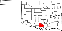 | |
| Towns | ||
| Unincorporated communities | ||
| Ghost towns | ||
| Footnotes | ‡This populated place also has portions in an adjacent county or counties | |
This article is issued from
Wikipedia.
The text is licensed under Creative Commons - Attribution - Sharealike.
Additional terms may apply for the media files.