Dummar
| Dummar Arabic: دمر | |
|---|---|
| Municipal district | |
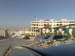 Residential homes in Dummar | |
 | |
| Coordinates: 33°53′00″N 36°23′20″E / 33.88333°N 36.38889°ECoordinates: 33°53′00″N 36°23′20″E / 33.88333°N 36.38889°E | |
| Country | Syria |
| City | Damascus |
| Population (2004) | |
| • Total |
96,962 [1] |
Dummar (Arabic: دمر) is a municipal district of Damascus, Syria, located in the northwest of the city. It is the largest district of Damascus in terms of area.[2]
History
The construction of the district was launched in the 1970s, with the first residents moved in during mid-1980s. Today it is a largely middle-class suburb home to many Damascene professionals.[3]
The municipality includes the Kurdish neighborhood of Wadi al-Mashari (Arabic: وادي المشاريع, Kurdish: Zorava, meaning Valley Projects)[4]
Since the beginning of the Syrian Civil War, it was largely known as the safest area of Damascus, and was the site of a charity marathon for children with cancer.[5]
Neighborhoods
- Al-Arin (pop. 14,285)
- Dahiyet Dummar (pop. 18,739)
- Dummar al-Gharbiyah (pop. 30,031)
- Dummar al-Sharqiyah (pop. 19,739)
- Al-Wuroud (pop. 14,167)
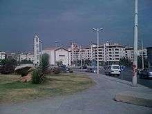 Dummar Church and Mosque in background
References
- ↑ Damascus governorate population 2004 census
- ↑ Enam Al-Wer; Rudolf Erik de Jong; Clive Holes (2009). Arabic Dialectology (Studies in Semitic Languages and Linguistics) (Hardcover ed.). Brill. p. 251. ISBN 90-04-17212-2.
- ↑ Catherine Miller; Enam Al-Wer; Dominique Caubet; Janet C.E. Watson (2007). Arabic in the city: issues in dialect contact and language variation (Hardcover ed.). Routledge. p. 193. ISBN 0-415-77311-3.
- ↑ "Kurds of Damascus: Trapped Between Secession and Integration".
- ↑ "Syrian charities battle corruption".
This article is issued from
Wikipedia.
The text is licensed under Creative Commons - Attribution - Sharealike.
Additional terms may apply for the media files.