Dumkibas
| Dumkibas | |
|---|---|
| Village development committee | |
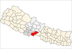
 Dumkibas Location in Nepal | |
| Coordinates: 27°35′N 83°53′E / 27.59°N 83.88°ECoordinates: 27°35′N 83°53′E / 27.59°N 83.88°E | |
| Country |
|
| Zone | Lumbini Zone |
| District | Nawalparasi District |
| Population (1991) | |
| • Total | 6,948 |
| Time zone | UTC+5:45 (Nepal Time) |
Dumkibas is a village development committee in Nawalparasi District in the Lumbini Zone of southern Nepal.
The longest highway of Nepal, Mahendra Highway, bisects this VDC into two parts. It lies between two rivers the Binai and the Jyameree. It is located at the foot hills of the Mahabharat range so the climate is cool compared to other area of the Terai. After end of the 10 years Maoist civil war, this area development is restless. A large section of youth are abroad for study and work. Most of people of here are engaged in trade and services, little in agriculture. This town is well developed as compared to other area of districts. All Black topped road, full literacy rate in recent years are the some of great achievement of this small town. Country biggest cement factory is providing a large number of jobs to the locals and is run by Chaudhary Group (CG). Daunne hill is the touristic place of this town. Also, different TV channel and radio channel broadcasting station is located at Daunne hill including (Nepal Television). Different banks, Hospital, school, colleges and wireless internet service provider are serving the locals well. In terms of security (Traffic Rules are very strict) this town is one of the safest area compared to other part of districts as the police station building is re-constructed which was destroyed by Maoists in civil war. Hence, Dumkibas is the example town for the districts.