Dry Cottonwood Creek (Deer Lodge County, Montana)
| Dry Cottonwood Creek | |
|---|---|
| Location | Deer Lodge County, Montana |
| Physical characteristics | |
| Main source | 46°12′39″N 112°39′01″W / 46.21083°N 112.65028°W |
| River mouth |
4,705 feet (1,434 m) 46°14′40″N 112°45′03″W / 46.24444°N 112.75083°WCoordinates: 46°14′40″N 112°45′03″W / 46.24444°N 112.75083°W[1] |
| Basin features | |
| River system | Columbia River |
Dry Cottonwood Creek is a creek in Deer Lodge County, Montana. Approximately 10 miles (16 km) long, it flows northwest out of the southern reaches of the Boulder Mountains into the Clark Fork river near Deer Lodge, Montana. Sapphires are found along this creek.[2]
Notes
- ↑ "Dry Cottonwood Creek". Geographic Names Information System. United States Geological Survey.
- ↑ Voynick, Stephen M. (1985). Yogo The Great American Sapphire (March 1995 printing, 1987 ed.). Missoula, MT: Mountain Press Publishing. p. 193. ISBN 0-87842-217-X.
Municipalities and communities of Deer Lodge County, Montana, United States | ||
|---|---|---|
| City | 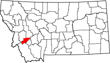 | |
| Neighborhoods | ||
| Ghost town | ||
This article is issued from
Wikipedia.
The text is licensed under Creative Commons - Attribution - Sharealike.
Additional terms may apply for the media files.