Druelle
| Druelle | |
|---|---|
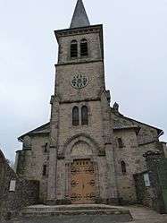 The church of Saint-Martin of Limouze, in Druelle | |
 Druelle Location within Occitanie region  Druelle | |
| Coordinates: 44°20′43″N 2°29′38″E / 44.3453°N 2.4939°ECoordinates: 44°20′43″N 2°29′38″E / 44.3453°N 2.4939°E | |
| Country | France |
| Region | Occitanie |
| Department | Aveyron |
| Arrondissement | Rodez |
| Canton | Vallon |
| Area1 | 35.68 km2 (13.78 sq mi) |
| Population (2008)2 | 1,941 |
| • Density | 54/km2 (140/sq mi) |
| Time zone | UTC+1 (CET) |
| • Summer (DST) | UTC+2 (CEST) |
| INSEE/Postal code | 12090 /12510 |
| Elevation |
392–666 m (1,286–2,185 ft) (avg. 500 m or 1,600 ft) |
|
1 French Land Register data, which excludes lakes, ponds, glaciers > 1 km2 (0.386 sq mi or 247 acres) and river estuaries. 2 Population without double counting: residents of multiple communes (e.g., students and military personnel) only counted once. | |
Druelle is a former commune in the Aveyron department in southern France. On 1 January 2017, it was merged into the new commune Druelle Balsac.[1]
Population
| Historical population | ||
|---|---|---|
| Year | Pop. | ±% |
| 1954 | 988 | — |
| 1962 | 784 | −20.6% |
| 1968 | 905 | +15.4% |
| 1975 | 958 | +5.9% |
| 1982 | 1,221 | +27.5% |
| 1990 | 1,420 | +16.3% |
| 1999 | 1,685 | +18.7% |
| 2008 | 1,941 | +15.2% |
See also
References
- ↑ Arrêté préfectoral 6 September 2016 (in French)
| Wikimedia Commons has media related to Druelle. |
This article is issued from
Wikipedia.
The text is licensed under Creative Commons - Attribution - Sharealike.
Additional terms may apply for the media files.