Drayton, Hampshire
| Drayton | |
|---|---|
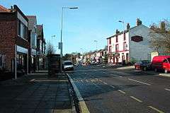 Drayton is astride a part-commercial, part-residential street, Havant Road | |
| Population | 13,054 (2011 Census. Drayton and Farlington Ward)[1] |
| Unitary authority | |
| Ceremonial county | |
| Region | |
| Country | England |
| Sovereign state | United Kingdom |
| Post town | PORTSMOUTH |
| Postcode district | PO6 |
| Dialling code | 023[2] |
| Police | Hampshire |
| Fire | Hampshire |
| Ambulance | South Central |
| EU Parliament | South East England |
| UK Parliament | |
Drayton is a residential area of the city of Portsmouth in the English county of Hampshire. Together with Farlington, its parent area, it makes up one of the electoral wards of the city.[n 1]
History
The earliest mention of Drayton was as a manor of Farlington parish. It appears in a document of the year 1250, when Henry III gave a moiety (legally fixed half share) of the land there to Roger de Merlay. Dreton appears as its form in the 14th century.[3]
Unlike the majority of the city, Drayton lies on the mainland rather than Portsea Island. The manor may be included under the Domesday Book of 1086's entry of Cosham; both were within decades confirmed as in Farlington parish.[4] The area including Drayton became incorporated into Portsmouth in 1920.[3] This followed a fast rise throughout the south of the original 4-mile (6.4 km) by 1 1⁄4-mile (2.0 km) strip parish in suburban and urban house building, and strong economic ties with the city.[3]
| “ | The hamlet of Drayton is now gradually developing into a residential locality. To the north of the road immediately past the New Inn is the Drayton building estate, on which new villas are rising steadily. South of the road is Drayton Manor, the residence of Lieut.-Col. Alfred Robert William Thistlethwayte, approached from the main road by Drayton Lane. — A History of the County of Hampshire: Volume 3, ed. William Page (London, 1908), pp. 148-151[3] | ” |
The New Inn survives and is protected under UK law in the initial category (grade II listing).[5] East of a mid-rise block of flats is a milestone, equally listed.[6]
Amenities
- Schools
- Court Lane Infant / Junior School
- Solent Junior School is in the adjoining area of Farlington.
- Springfield School
- Anglican Community centre
In the Church of England the Church of the Resurrection and its hall is at the end of a short avenue north of Havant Road.[7] The foundation stone was laid on 22 April 1930, by Lady Heath Harrison, the Bishop of Portsmouth attending. It includes a food bank and regular fairtrade goods market.[8]
- United Reformed and Methodist centre
Drayton United Church is a joint Methodist and United Reformed Church on Havant Road; its building has all of its windows and their casements in the medieval style and it was built in the early 20th century.[9]
- Nearest other places of worship and religious community
In the Catholic Church St Colman's Church and its Hall are in Cosham, in green landscaped grounds, 600 metres west from the above church, equally on Havant Road.[10]
Former station
Station Road, Drayton (there is another Station Road in Copnor ward) once served the now-demolished Farlington Racecourse station which closed in 1938. Likewise, that intended for Station Road, Copnor was never built, so Portsmouth has two Station Roads without stations.
References
- References
- ↑ "Portsmouth ward population 2011". Neighbourhood Statistics. Office for National Statistics. Retrieved 14 December 2016.
- ↑ Dialling codes Ofcom (the UK Government office for and regulator of communications)
- 1 2 3 4 'Parishes: Farlington', in A History of the County of Hampshire: Volume 3, ed. William Page (London, 1908), pp. 148-151. British History Online http://www.british-history.ac.uk/vch/hants/vol3/pp148-151 [accessed 25 May 2018].
- ↑ 'The hundred of Portsdown: Introduction', in A History of the County of Hampshire: Volume 3, ed. William Page (London, 1908), pp. 140-141. British History Online http://www.british-history.ac.uk/vch/hants/vol3/pp140-141 [accessed 25 May 2018].
- ↑ Historic England. "Details from listed building database (1333210)". National Heritage List for England.
- ↑ Historic England. "Details from listed building database (1333211)". National Heritage List for England.
- ↑ https://www.achurchnearyou.com/church/16751/
- ↑ https://www.achurchnearyou.com/church/16751/facilities/
- ↑ East Solent and Downs Methodist Churches website
- ↑ http://stcolmans-stpauls.co.uk/?page_id=118
- Notes
- ↑ See in date order: ecclesiastical parish, select vestry and civil parish.