Dr Ivan Ribar
| Dr Ivan Ribar Др Иван Рибар | |
|---|---|
| Urban neighbourhood | |
 Dr Ivan Ribar | |
 Dr Ivan Ribar Location within Belgrade | |
| Coordinates: 44°48′02″N 20°22′02″E / 44.80056°N 20.36722°ECoordinates: 44°48′02″N 20°22′02″E / 44.80056°N 20.36722°E | |
| Country |
|
| Region | Belgrade |
| Municipality | New Belgrade |
| Local community | 25 June 2014 |
| Area | |
| • Total | 7.36 km2 (2.84 sq mi) |
| Time zone | UTC+1 (CET) |
| • Summer (DST) | UTC+2 (CEST) |
| Area code | +381(0)11 |
| Car plates | BG |
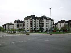
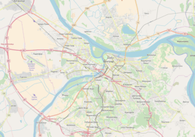
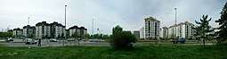
Dr Ivan Ribar (Serbian Cyrillic: Др Иван Рибар) is an urban neighborhood of Belgrade, the capital of Serbia. It is located in Belgrade's municipality of New Belgrade.
Location
Dr Ivan Ribar is located in the western outskirts of Novi Beograd, as the last neighborhood in that direction. It is narrow and rectangle shaped, bordered on the east by the Dr Ivan Ribar street and the neighborhood of Blokovi, and on the west by the mostly uninhabited field of Jasenovo. On the south it borders the embankment on the Sava river.
History
As one of the last neighborhoods in Novi Beograd built before the collapse of Serbian economy in the early 1990s, it initially was known only by the name, but later block numbers were assigned to it (like for the most of Novi Beograd) so the southern part of the neighborhood is now Block 71 and northern one is Block 72, so far the two highest numbers of all the blocks.
On 25 June 2014, municipal assembly of New Belgrade voted to establish the new local community, Dr Ivan Ribar. It occupies the southwest corner of New Belgrade, bordering the municipality of Surčin. Formed from the parts of the Bežanija Blocks and Sava local communities, it also occupies the Savski Nasip riparian zone.[1][2]
Characteristics
The neighborhood is entirely residential. A gravel selling facility is located on the bank of the Sava river, across the embankment.
A roundabout at the end of the neighborhood is a final stop for public transportation lines connecting the neighborhood with the downtown: buses number 73, 94, 95 and 604 and trams number 7, 9 and 11.
The wide area between the buildings closest to the river and the embankment is covered with waste and garbage which gives a very ugly picture of the neighborhood, but this 10-year-old unofficial landfill is also an environmental concern, especially with frequent fires.
Dr Ivan Ribar was named after the Croatian-Yugoslav politician, Ivan Ribar (1881–1968).
Sports center
City government designated an area of 25 hectares in the neighborhood for the future sports center. It is supposed to be entirely dedicated to the athletics, with an athletic stadium, one of only few in this part of Europe (other two are in Athens and Budapest). It would also include smaller stadium for warming up, auxiliary sports objects, a hotel and a tennis playground. Even though it was planned that complex will be finished by 2009 so it could be used during the 2009 Summer Universiade in Belgrade, as of August 2006 not just that construction didn't start, but even the project is still not being completed.
References
Sources
- Beograd - plan grada [Belgrade - city map] (Map). 1:20,000. COBBISS.SR-ID 132560908 (in Serbian). Novi Beograd: Magic Map. 2006. ISBN 86-83501-53-1.
|