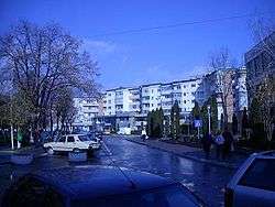
Drăgășani
| Drăgășani | ||
|---|---|---|
| Municipality | ||
 | ||
| ||
 Drăgășani Location of Drăgășani | ||
| Coordinates: 44°39′40″N 24°15′38″E / 44.66111°N 24.26056°ECoordinates: 44°39′40″N 24°15′38″E / 44.66111°N 24.26056°E | ||
| Country |
| |
| County | Vâlcea County | |
| Status | Municipality | |
| Government | ||
| • Mayor | Cristian Nedelcu (Social Democratic Party) | |
| Area | ||
| • Total | 44,57 km2 (1,721 sq mi) | |
| Population (2002)[1] | ||
| • Total | 22,948 | |
| • Density | 5.1/km2 (13/sq mi) | |
| Time zone | UTC+2 (EET) | |
| • Summer (DST) | UTC+3 (EEST) | |
| Climate | Cfb | |
| Website | http://www.primariadragasani.ro/ | |
Drăgășani (Romanian pronunciation: [drəɡəˈʃanʲ] (![]()
The city administers four villages: Capu Dealului, Valea Caselor, Zărneni and Zlătărei. It is situated in the historical region of Oltenia.
History
| Historical population | ||
|---|---|---|
| Year | Pop. | ±% |
| 1900 | 4,398 | — |
| 1912 | 6,710 | +52.6% |
| 1930 | 7,002 | +4.4% |
| 1948 | 9,737 | +39.1% |
| 1956 | 9,963 | +2.3% |
| 1966 | 11,589 | +16.3% |
| 1977 | 15,647 | +35.0% |
| 1992 | 22,126 | +41.4% |
| 2002 | 22,499 | +1.7% |
| 2011 | 16,681 | −25.9% |
| Source: Census data | ||
Drăgășani stands on the site of the Daco-Roman Rusidava. On 19 June 1821, during the Greek War of Independence, the Ottomans routed the Filiki Eteria troops of Alexander Ypsilantis near the city in the Battle of Dragashani.[2] There Tudor Vladimirescu fought with his Panduri, revolutionary fighters consisting mainly of peasants and not armed with firepower, against the Turks.
Natives
- Florin Costea
- Mihai Costea
- Alexandru Dandea
- Mugur Isărescu
- Gib Mihăescu
- Paraschiv Oprea
Notes
| Wikimedia Commons has media related to Drăgășani. |
- ↑ "Rezultatele recensământului din 2002 pentru Drăgășani, Vâlcea".
- 1 2

