Doyo Dam
| Doyo Dam | |
|---|---|
 | |
 Location of Doyo Dam in Japan | |
| Country | Japan |
| Location | Shinjō |
| Coordinates | 35°13′53″N 133°32′42″E / 35.23139°N 133.54500°ECoordinates: 35°13′53″N 133°32′42″E / 35.23139°N 133.54500°E |
| Construction began | 1978 |
| Opening date | 1986 |
| Owner(s) | Chugoku Electric Power Company |
| Dam and spillways | |
| Type of dam | Embankment, rock-fill |
| Height | 86.7 m (284 ft) |
| Length | 480 m (1,575 ft) |
| Dam volume | 2,650,000 m3 (3,466,069 cu yd) |
| Reservoir | |
| Total capacity | 7,680,000 m3 (6,226 acre⋅ft) |
| Active capacity | 6,700,000 m3 (5,432 acre⋅ft) |
| Catchment area | 1.8 km2 (445 acres) |
| Surface area | 30 ha (74 acres) |
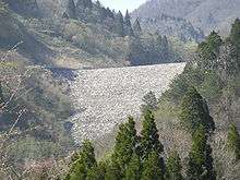
Doyo Dam (Japanese: 土用ダム) is a rock-fill embankment dam located 6 km (4 mi) north of Shinjō in the Okayama Prefecture, Japan. It creates the upper reservoir for the 1,500 MW Matanoagawa Pumped Storage Power Station while the Matanoagawa Dam creates the lower.[1]
References
- ↑ "Doyo Dam" (in Japanese). Dam Net. Retrieved 26 January 2012.
This article is issued from
Wikipedia.
The text is licensed under Creative Commons - Attribution - Sharealike.
Additional terms may apply for the media files.