Dovenby Hall
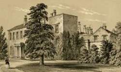
Dovenby Hall is a country house in 115 acres (47 ha) of land at Dovenby, about 2 miles (3.2 km) north-west of Cockermouth, Cumbria, England. It is a Grade II listed building.[1]
History
The oldest part of the estate is a 13th-century peel tower.[1] The main house was built for Sir Thomas Lamplugh in the 16th century and, after the house came into the ownership of the Dykes family in about 1800,[2] it was remodelled for the Ballentine-Dykes family in the early 19th century.[1]
Joseph Dykes Ballantine Dykes was High Sheriff of Cumberland for 1807-08 and resided in the house. His eldest son Fretcheville Lawson Ballantine-Dykes served as Member of Parliament for Cockermouth from 1832 to 1836 .[3] The property passed down to Frecheville Hubert Ballantine-Dykes, an Army officer and High Sheriff for 1923–24.[4]
A family member was Chairman of the Maryport and Carlisle Railway in the 1840s.[5] A private station named Dovenby Lodge was provided for the family's use. It closed and the line was lifted in 1935.[6]
The house was acquired by the local authorities from Colonel Ballantine-Dykes for use as a mental hospital in 1930.[7] Following the closure of the hospital, it was bought by Malcolm Wilson, a former rally driver, in January 1998 and, after a major refurbishment, then became home to Ford's World Rally Championship team.[7]
See also
- The Dykes family
References
- 1 2 3 "Dovenby Hall and Adjoining Rear Wing, Bridekirk". British listed buildings. Retrieved 19 July 2015.
- ↑ "Some portraits at Dovenby Hall". Transactions of the Cumberland and Westmorland Antiquarian & Archaeological Society. 1964. Retrieved 19 July 2015.
- ↑ "Dykes, Frecheville Lawson Ballantine of Dovenby Hall, Cockermouth". History of Parliament. Retrieved 19 July 2015.
- ↑ "No. 32805". The London Gazette. 13 March 1923. p. 1989.
- ↑ Suggitt 2008, p. 96
- ↑ Suggitt 2008, p. 97
- 1 2 "Dovenby Hall History". M Sport. Retrieved 19 July 2015.
Sources
- Suggitt, Gordon (2008). Lost Railways of Cumbria (Railway Series). Newbury: Countryside Books. ISBN 978-1-84674-107-4.