Dornala
| Dornala Pedda.Dornala Thoranala, Diguva Srisailam | |
|---|---|
| Village | |
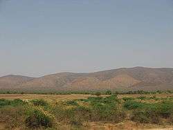 Nallamalla Hills near Dornala | |
| Nickname(s): Thoranala | |
 Dornala Location in Andhra Pradesh, India  Dornala Dornala (India) | |
| Coordinates: 15°54′00″N 79°06′00″E / 15.9000°N 79.1000°ECoordinates: 15°54′00″N 79°06′00″E / 15.9000°N 79.1000°E | |
| Country | India |
| State | Andhra Pradesh |
| District | Prakasam |
| Mandal | Dornala,Bandaru village |
| Elevation | 208 m (682 ft) |
| Languages | |
| • Official | Telugu, Hindhi |
| Time zone | UTC+5:30 (IST) |
| Vehicle registration | AP |
Dornala(Thoranala) is a village in Prakasam district of the Indian state of Andhra Pradesh. It is the mandal headquarters of Dornala mandal in Markapur revenue division.[1] Toll time 9pm to 6 am
Geography
Doranala is located at 15°54′00″N 79°06′00″E / 15.9000°N 79.1000°E.[2] It has an average elevation of 208 meters (685 feet).
Transport
The National Highway 765 passes though the village, which connects Hyderabad and Tokapalle road of Andhra Pradesh.[3]
References
- ↑ "Prakasam District Mandals" (PDF). Census of India. pp. 118, 171. Retrieved 19 June 2015.
- ↑ "Maps, Weather, and Airports for Doranala, India". fallingrain.com.
- ↑ "List of National Highways passing through A.P. State". Roads and Buildings Department. Government of Andhra Pradesh. Retrieved 11 February 2016.
| Wikimedia Commons has media related to Dornala. |
This article is issued from
Wikipedia.
The text is licensed under Creative Commons - Attribution - Sharealike.
Additional terms may apply for the media files.