Dorestad

Dorestad was an early medieval emporium, located in the southeast of the province of Utrecht in the Netherlands, close to the modern-day town of Wijk bij Duurstede. The township was established at the base of the former Roman fortress of Levefanum in the 7th century, and was situated near the point where the Nederrijn, the northernmost branch of the Rhine, splits into the Lek and the Kromme Rijn.
History
The settlement was included in the northeastern shipping routes due to its proximity to the fork in the Rhine, with access to Germany (via the Nederrijn), to the southern Netherlands, northern France, and England (via the Lek), and to the northern Netherlands, northern Germany, and Scandinavia (via the Kromme Rijn). Initially, the Frankish Carolingian Empire and the Frisians fought for control of the territory. However, the Franks gained control of the Frisian Coast in 719.
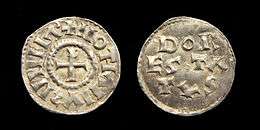
Dorestad flourished between the 7th century and the mid- 9th century. The settlement was well known for minting coins under the control of several Frankish rulers. It is generally believed that the township reached its peak around the 820s and the 830s and declined considerably thereafter. It is thought that the decline occurred because of Viking invasions as well as a decline in the economy.[1]
By the 9th century, it seems that the need for international trade was waning as regional trade gained importance. The majority of the information known about the emporium comes from a combination of historical documents, archaeological finds and numismatic evidence.
Excavation
To find out more about the settlement and its prominence in the early Middle Ages the site was excavated. Some excavations took place in the middle of the nineteenth century and the finds from them are now in the National Museum and the British Museum.[2] The most important findings were discovered during an excavation that took place between 1967 and 1977.[3] About 30 hectare were exposed during the excavation and much was learned about the physical parameters of the settlement. It was discovered Dorestad was situated one mile north of Wijk bij Duurstede and was approximately 3 square kilometres in size. This is considered a large settlement for the time period.
It is believed that the settlement was separated into three districts: a harbour (“Lower town”), a trading centre located on the left bank (“Upper town”), and an agricultural area located further inland.[1] Upper and lower town were connected by a single road which acted as the ‘backbone’ of the town. The remnants of this road can still be seen today.
Only the "lower town" was excavated by archaeologists as much of Dorestad was eroded away by the river bend. When the harbour was excavated the remains of wooden causeways which would have allowed for easy unloading of goods were discovered. These findings correlate to the development of trade on the Rhine. It is believed that wine from the vineyards South of Mainz was one of the most prominent products traded in Dorestad.[4] Old wine barrels have been excavated in Dorestad. It is also thought that glassware and lava querns for grinding corn were also transported to Dorestad for trading. The existence of these imports allowed Dorestad’s economy to grow substantially.
While the "upper town" was never excavated, the soil of the site has been examined and tested positive for phosphates that confirm its existence. Some Carolingian artefacts have been found over the years in the trading centre; however, the majority of items discovered date back to the Roman fortress that was established prior to the 7th Century. This may be because the residents of Dorestad used the tufa blocks from the Roman fortress as building material.[1] It is thought that the royal administrators were situated in the Upper Town.
The Christian church was granted a piece of land in both the Upper and Lower Town. Next to the agricultural sector remains of a building were found as well as many graves. It is assumed that this area comprised the Lower church.[1]
The conception of the Upper and Lower township is supported not only by archaeological evidence, but a poem was discovered by the English clergyman Alcuin, written at the end of the 8th Century, referring to the town as ‘Dorstata’ which is a pluralization of the name.[1]
- Hinc tua vela leva, fugiens Dorstada relinque:
- Non tibi forte niger Hrotberct parat hospita tecta,
- Nec amat ecce tuum carmen mercator avarus.
- Hoist your sails, flee and leave behind the (towns of) Dorestad:
- You do not have the fortune of a hospitable roof offered by Black Hrotberct,
- Nor does the greedy merchant love your poem.
Rise and fall
In the 7th century, it was clear that Dorestad had the potential to become a major port. It was the meeting point for traders at the time. As a result, the Franks and the Frisians fought over control of the township. The Franks won out at the end of the 7th century and closely monitored the growth of Dorestad, which led to Dorestad's economic expansion via international trade and the establishment of a mint in the Upper town. It is assumed that there was a toll as well as harbour fees, collected by the king’s representatives at Dorestad.[1] Over time, many coins have been discovered in the Dorestad area, supporting the idea of rapid growth and control of the harbour as well as the presence of a mint.[5] Many of the coins that have been discovered bear resemblance to other Frankish coins of the period. The numismatic evidence supports the victory of the Franks over the Frisians.[6]
It seems that the expansion of Dorestad, Lower Town in particular, lasted until the early 9th century, when the strength of the international trade of luxury items was weakened by the rise of regional trade. The shift in the character of trade occurred as more and more trading towns popped up in the region. The Franks seemed to be networking with Byzantium and the Muslim world. As the trade increased across the board, the Franks required more trading settlements to support the economy.[7]
As a result, the Franks slowly lost interest in the town and granted the Church of Utrecht responsibility over a sizeable portion of Dorestad. By expanding the power of the Church, the local élite was weakened providing substantial security for the Franks.[1]
By the 830s, under the control of Louis the Pious, the expansion of the harbour had halted altogether, but coins continued to be minted for some time. A division occurred in the Frankish Empire, and Louis the Pious was removed from the throne by his son. However, Lothair I was unable to protect Dorestad and the other Frankish territories from economic turmoil. As a result, Louis the Pious quickly took back Dorestad and exiled his son to Italy. At this time, two things occurred in Dorestad that led to its eventual downfall.
The first was that the Franks lost even more interest in Dorestad and as a result, even more control was transferred to the Church. The second was that Lothair I was stirring up trouble for the Franks by encouraging Viking raids on the Frisian coast when he was exiled. Between 834 and 839, there were extensive raids.[1] Although Dorestad was raided only once, in 834, it seems that the town never fully recovered afterwards.[1]
To protect the Frisian coastline, Frankish kings enlisted the help of the Danes and appointed Haraldr Junior and his brother, Hroerekr, to protect the emporium.[1]
Eventually in 840, the threat of the Vikings receded, as a truce was reached. The Franks no longer needed the help of the Danes and began to look for ways to dispose of them. That created conflict between the Franks and the Danes as Hroerekr established a gang of men to attack the coast. In 846, Dorestad and two other settlements were plundered.[1] While Frankish defence was organized, that did not stop the Danes from capturing Dorestad and a large portion of the Frisian Coast in 850.[1]
The Franks allowed Hroerekr to take control of the land as long as he protected the coast from Viking invasions. The coast was battered by Viking attacks, but it seems that Dorestad was left relatively unscathed. The Danish rulers held court on the coast for quite some time despite being not well liked by the people that they ruled.
Under Danish control, Dorestad became less significant. Trading had slowed and now was almost nonexistent. The mint was shut down when Hroerekr took control of the lands. As the settlement no longer held much economic or cultural significance, the populace of Dorestad thinned, and the place became a dimly-remembered part of history.
See also
References
- 1 2 3 4 5 6 7 8 9 10 11 12 Luit van der Tuuk (2005). "Danes in Dorestad. Gjaller Norsemen in the Low Countries". Archived from the original on 2 May 2014. Retrieved 29 October 2013.
- ↑ British Museum Collection
- ↑ The Early-Medieval harbour of Dorestad. N.p., n.d. Web. 1 Nov. 2013. Archived March 8, 2008, at the Wayback Machine.
- ↑ Hodges, Richard. Mohammed, Charlemagne & the Origins of Europe: Archaeology and the Pirenne Thesis. N.p.: Cornell University Press, 1983. 99-100. Google Books. Web. 1 Nov. 2013
- ↑ Coupland Simon (2003). "Trading places: Quentovic and Dorestad reassessed". Early Medieval Europe. 11: 209–232. doi:10.1046/j.0963-9462.2002.00109.x.
- ↑ Van Der Tuuk, Lute. Dorestad Revealed. N.p., 2010. Web. 1 Nov. 2013.
- ↑ McCormick, Michael. Origins of The European Economy. Cambridge: Cambridge University Press, 2001. 610-12. Print.