Doonmore
| Doonmore | |
|---|---|
|
Native name Irish: An Dún Mór | |
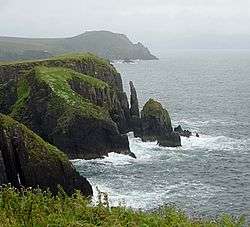 View of the fort | |
| Type | promontory fort |
| Etymology | great fort |
| Location | Doonsheane, Dingle Peninsula, County Kerry |
| Coordinates | 52°07′08″N 10°13′18″W / 52.118803°N 10.221626°WCoordinates: 52°07′08″N 10°13′18″W / 52.118803°N 10.221626°W |
| Area | 2.93 ha (7.2 acres) |
| Built | 5th–8th centuries |
| Owner | state |
| Official name: Doonmore Promontory Fort | |
| Reference no. | 221.45 |
 Location of Doonmore in Ireland | |
Doonmore is a promontory fort and National Monument located in County Kerry, Ireland.[1][2]
Location
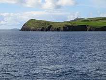
Doonmore from the water
Doonmore lies on a headland reaching into Dingle Bay, 4 km (2.5 mi) southeast of Dingle town.[3]
History
Traditionally viewed as being built by the Iron Age Veneti, promontory forts are now associated with a later date, the early Middle Ages. (5th–8th centuries AD)
Structure
A headland of 2.93 ha (7.2 acres), cut off from the mainland by an artificial ditch, with complex multiple vallations and stone ramparts.[4]
References
- ↑ "The Transactions of the Royal Irish Academy". 28 June 2018 – via Google Books.
- ↑ Westropp, T. J. (28 June 2018). "The Ancient Forts of Ireland". Рипол Классик – via Google Books.
- ↑ "Promontory fort. Dingle, 'Doonmore', Kerry, Ireland – aerial photo". www.cambridgeairphotos.com.
- ↑ http://www.epa.ie/licences/lic_eDMS/090151b2806038e1.pdf
This article is issued from
Wikipedia.
The text is licensed under Creative Commons - Attribution - Sharealike.
Additional terms may apply for the media files.