Donakonda
| Donakonda | |
|---|---|
| Village | |
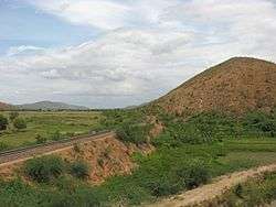 Vinukonda- Nandyal train section passes through Donakonda | |
 Donakonda Location in Andhra Pradesh, India  Donakonda Donakonda (India) | |
| Coordinates: 15°50′00″N 79°29′00″E / 15.8333°N 79.4833°ECoordinates: 15°50′00″N 79°29′00″E / 15.8333°N 79.4833°E | |
| Country | India |
| State | Andhra Pradesh |
| District | Prakasam |
| Mandal | Donakonda |
| Population (2011) | |
| • Total | 2,028 |
| Languages | |
| • Official | Telugu |
| Time zone | UTC+5:30 (IST) |
| PIN | 523305 |
| Vehicle registration | AP |
Donakonda is a village in Prakasam district of the Indian state of Andhra Pradesh. It is located in Donakonda mandal in Kandukur revenue division.[1]
Geography
Donakonda is located at 15°50′00″N 79°29′00″E / 15.8333°N 79.4833°E in Prakasam district. The land is mostly flat though hilly country begins some distance away.
Transport
Donakonda Railway Station is a station on the Guntur-Guntakal railway line and falls under the Guntur division of South Central Railway. Donakonda Airport (ICAO: VODK) is located at Donakonda in Andhra Pradesh, India. The airfield was constructed during World War II by the British regime to refuel its aircraft.[1] It is owned by the Airports Authority of India and is closed. Now the ap government handeover the donakonda airport to Bogpuram airport authority and the extension of airport project is going on.
References
- ↑ "Chittoor District Mandals" (PDF). Census of India. pp. 120, 171–72. Retrieved 19 June 2015.
External links
| Wikimedia Commons has media related to Donakonda. |