Dolores River Bridge
| Dolores River Bridge | |
|---|---|
 | |
| Coordinates | 38°18′30″N 108°52′54″W / 38.30833°N 108.88167°WCoordinates: 38°18′30″N 108°52′54″W / 38.30833°N 108.88167°W |
| Carries |
|
| Crosses | Dolores River |
| Locale | Near Bedrock, Colorado |
| Characteristics | |
| Design | Through truss |
| Total length | 125 ft (38.1 m) |
| Width | 23.9 ft (7.3 m) |
| Longest span | 128.9 ft (39.3 m) |
| Clearance above | 15.6 m (51.2 ft) |
| History | |
| Construction end | 1952 |
| Opened | 1952 |
| Statistics | |
| Daily traffic | 319 (as of 2003) |
|
Dolores River Bridge | |
| Built | 1952 |
| Architect | Colorado Department of Highways |
| Architectural style | Pennsylvania through truss |
| MPS | Highway Bridges in Colorado MPS |
| NRHP reference # | 02001150[1] |
| Added to NRHP | October 15, 2002 |
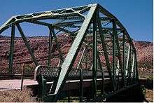
The Dolores River Bridge is a through truss bridge spanning the Dolores River near Bedrock, Colorado, United States. It carries State Highway 90 and is listed on the National Register of Historic Places.[1]
It was designed by the Colorado Department of Highways and was fabricated by Midwest Steel & Iron Works. It was installed in 1952 by contractor Gardner Construction Company. It is located at milepost 15.22, 0.4 miles east of Bedrock. Its structure is 129 feet (39 m) long and 25.1 feet (7.7 m) wide, with main span of 125 feet (38 m) and roadway width of 24 feet (7.3 m).[2]
References
- 1 2 National Park Service (2010-07-09). "National Register Information System". National Register of Historic Places. National Park Service.
- ↑ "National Register of Historic Places Registration: Dolores River Bridge / CDOT No. K-01-C: 5MN4". National Park Service. Retrieved July 26, 2017. With two photos.
This article is issued from
Wikipedia.
The text is licensed under Creative Commons - Attribution - Sharealike.
Additional terms may apply for the media files.