Dolná Ves
| Dolná Ves | |
| Village | |
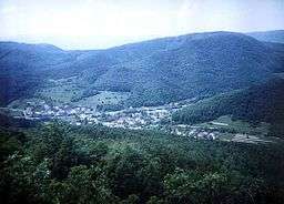 Dolná Ves as seen from Ďurova Skala | |
| Country | Slovakia |
|---|---|
| Region | Banská Bystrica |
| District | Žiar nad Hronom |
| Coordinates | 48°39′56″N 18°54′45″E / 48.66556°N 18.91250°ECoordinates: 48°39′56″N 18°54′45″E / 48.66556°N 18.91250°E |
| Area | 2.37 km2 (0.92 sq mi) |
| Population | 249 (31 Dec 2011) |
| Density | 105/km2 (272/sq mi) |
| First mentioned | 1429 |
| Mayor | Milan Pračko (independent) |
| Timezone | CET (UTC+1) |
| - summer (DST) | CEST (UTC+2) |
| Postal code | 967 01 |
| Area code | +421-45 |
| Car plate | ZH |
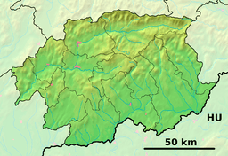 Location of Dolná Ves in the Banská Bystrica Region  Dolná Ves (Slovakia) | |
| Wikimedia Commons: Dolná Ves | |
| Statistics: MOŠ/MIS | |
Dolná Ves (before 1948(?): Šváb, older: Šváby; German: Schwabendorf; Hungarian: Sváb) is a village and municipality in Žiar nad Hronom District in the Banská Bystrica Region of central Slovakia. It is near the town of Kremnica.
The first written record about the village is from the year 1427 (Schwabendorff), when the village became the property of Kremnica. Dolná Ves was part of Kremnica in the Middle Ages and from 1808 to 1882. The village was founded by German colonists.
Gallery
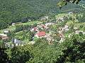 View from a nearby hill
 Žliebok
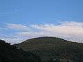 Ďurova Skala, Kremnica Mountains
 Jastrabská skala, Kremnica Mountains
 The church
 Statue of Saint John Nepomucene
Genealogical resources
The records for genealogical research are available at the state archive "Statny Archiv in Banska Bystrica, Slovakia"
- Roman Catholic church records (births/marriages/deaths): 1674-1913 (parish B)
- Lutheran church records (births/marriages/deaths): 1666-1891 (parish B)
See also
External links
- https://web.archive.org/web/20080111223415/http://www.statistics.sk/mosmis/eng/run.html.
- http://www.e-obce.sk/obec/dolnaves/dolna-ves.html
- Surnames of living people in Dolna Ves
This article is issued from
Wikipedia.
The text is licensed under Creative Commons - Attribution - Sharealike.
Additional terms may apply for the media files.